Kansai Airport in a Super Typhoon
Updated September 5, 2018 Starting at 6 AM this morning, thousands of passengers stranded at Kansai International Airport can take ferries to Kobe Airport, which was largely unaffected by the disaster. Each ferry carries 110 people, with departures every 15-20 minutes. Checking NOTAMs revealed that nearby Kobe Airport and Osaka Itami Airport were not significantly affected by the typhoon and may be able to absorb some of the passenger traffic from Kansai Airport. Media reports suggest that it may take six months to fully restore the road and rail bridge to its pre-accident capacity, but airport flights are expected to resume within a week. By 8 AM, passenger transport via buses across the road bridge had begun. By 11 PM, the airport operator officially announced that all 7,800 people stranded at the airport had been evacuated (except for 25 people who wished to continue waiting at the airport).
Updated September 6, 2018 Since Runway B and the second terminal were not significantly damaged, partial domestic flight operations will commence from September 7.
Kansai International Airport is Japan’s second-largest international airport, the first in Japan to operate 24 hours a day, and the world’s first international airport to operate on a private (public-private partnership) basis. Officially opened on September 4, 1994, flights cover more than 80 cities worldwide, with a maximum of 1,241 flights per week. In 2017, the total passenger volume was 20.9 million, with a daily average of 78,000. Kansai Airport is also a vital trade transport center, with annual export trade volume exceeding $50 billion. The airport has two runways; Runway A is 3,500 meters long, and during this typhoon, Runway A and the surrounding Taxiway area were flooded. There is another 4,000-meter-long Runway B, which can be used normally.
Nikkei Chinese Edition: Why is Kansai Airport so vulnerable?
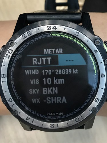
Super Typhoon Jebi struck. Yahoo News reported that Kansai Airport had closed. During my lunch break, I checked the weather information at various airports.
It was intense. The METAR at Kansai Airport showed wind speeds reaching 57-73 knots, which means a maximum speed of 135 km/h. No wonder the airport had to shut down.
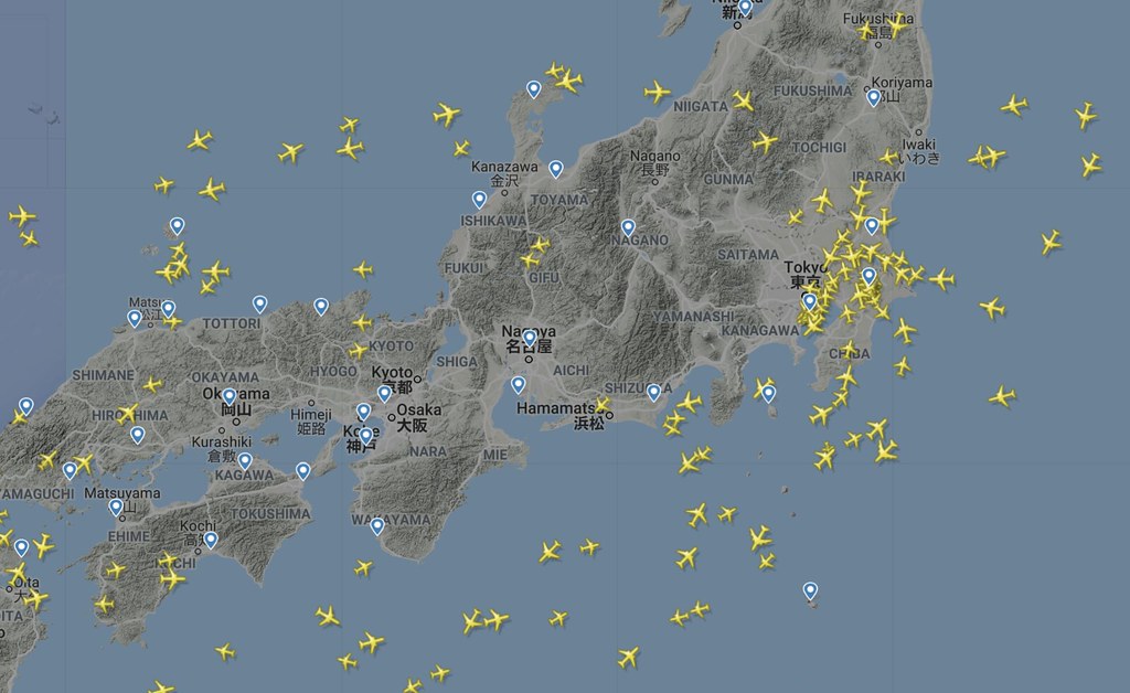
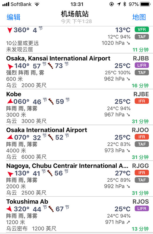 I opened FlightRadar24 to check and found, sure enough, there wasn’t a single plane in the sky over Osaka and Nagoya.
NOTAM
0887/18 NOTAMN Q)RJJJ/QSTLC/IV/NBO/A/000/999/3426N13514E005 A)RJBB B)1809040420 C)UFN E)TWR-CLSD DUE TO TYPH EVACUATION
I checked the weather again more than ten minutes later, and the wind speed had reached 80-99 knots, or 183 km/h. Terrifying.
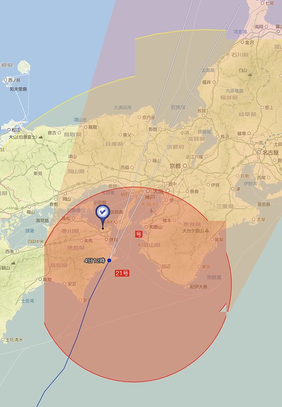
 At this point, the location of the typhoon’s center could also be seen on Yahoo Maps:
RJBB 040430Z 19080G99KT 0500 R24L/0175V0550D R24R/1400VP2000D +SHRA FG FEW003 SCT008 BKN020CB 25/25 Q0956 NOSIGRJBB 040426Z 19071G99KT 0600 R24L/0275V0550N R24R/0350VP2000U +SHRA FG SQ FEW003 SCT008 BKN020CB 25/25 Q0957 RMK 1ST003 3ST008 5CB020 A2827 CB OHD MOV N P/FR RI++
RJBB 040423Z 18064G99KT 0600 R24L/0300V0900D R24R/0350VP2000U +SHRA FG FEW003 SCT008 BKN020CB 25/25 Q0960 RMK 1ST003 3ST008 5CB020 A2835 CB OHD MOV N P/FR RI++
RJBB 040415Z 14057G73KT 0600 R24L/0325V0900U R24R/0300V0750U +SHRA FG FEW003 SCT008 BKN020CB 25/25 Q0962 RMK 1ST003 3ST008 5CB020 A2841 CB OHD MOV N P/FR RI++
RJBB 040412Z 13047G68KT 0300 R24L/0325V0650N R24R/0300V0550U +SHRA FG FEW003 SCT008 BKN020CB 25/25 Q0963 RMK 1ST003 3ST008 5CB020 A2844 CB OHD MOV N P/FR RI++
RJBB 040400Z 12046G58KT 0500 R06R/0300V0750D R06L/0225V0500N +SHRA FG FEW005 SCT015 BKN020CB 26/25 Q0966 BECMG FM0430 16050G70KT
Then came an even bigger tragedy. Look at the NOTAM:
NOTAM RJBB 0889/18 FROM 18/09/04 04:56 TO UFN E)METAR/SPECI NOT PROVIDED DUE TO TROUBLEThe storm caused a malfunction in the weather observation facilities, so they couldn't even provide METARs anymore! I suspect the wind speed exceeded 100 knots after that. Perhaps this is the fate of an artificial offshore airport.
Later, I saw RVR, wind socks, anemometers, DME, and ILS fail one after another. The violence of this typhoon completely exceeded my imagination.
0909⁄18 FROM 18/09/04 08:54 TO 18/09/05 01:00EST E)KANSAI VOR/DME/KNE-U/S DUE TO TROUBLE0906⁄18 FROM 18/09/04 08:52 TO 18/09/05 01:00EST E)ILS-LOC,GP,IM FOR RWY 06R-U/S DUE TO TROUBLE
0905⁄18 FROM 18/09/04 08:51 TO 18/09/05 01:00EST E)ILS-LOC,GP,IM FOR RWY 06L-U/S DUE TO TROUBLE
0904⁄18 FROM 18/09/04 08:51 TO 18/09/05 01:00EST E)ILS-LOC,GP,IM FOR RWY 24R-U/S DUE TO TROUBLE
0903⁄18 FROM 18/09/04 08:51 TO 18/09/05 01:00EST E)ILS-LOC,GP,IM FOR RWY 24L-U/S DUE TO TROUBLE
0901⁄18 FROM 18/09/04 06:09 TO UFN E)RVR DATA FOR RWY 06R/24L MID NOT PROVIDED DUE TO TROUBLE
0900⁄18 FROM 18/09/04 06:08 TO UFN E)RVR DATA FOR RWY 24L THR SIDE NOT PROVIDED DUE TO TROUBLE
0899⁄18 FROM 18/09/04 05:56 TO UFN E)LOW LVL WIND SHEAR ADVS BY DOPPLER LIDAR NOT PROVIDED DUE TO TROUBLE
0898⁄18 FROM 18/09/04 06:00 TO UFN E)AD-CLSD DUE TO FLOOD
FROM 18/09/04 05:29 TO UFN E)WIND DIRECTION AND SPEED DATA FOR RWY 24L THR SIDE NOT PROVIDED DUE TO TROUBLE
0895⁄18 FROM 18/09/04 05:18 TO UFN E)TWR-CLSD DUE TO TYPH EVACUATION RMK/(1)ATC SERVICE IS AVBL (2)AVBL TWR FREQ 118.2MHZ 121.5MHZ
0894⁄18 FROM 18/09/04 05:05 TO 18/09/04 09:00EST E)DME PORTION OF KANSAI VOR/DME/KNE-U/S DUE TO TROUBLE
0893⁄18 FROM 18/09/04 05:05 TO 18/09/04 09:00EST E)ILS-LOC,GP,IM FOR RWY 06R-U/S DUE TO TROUBLE
0892⁄18 FROM 18/09/04 05:04 TO 18/09/04 09:00EST E)ILS-LOC,GP,IM FOR RWY 06L-U/S DUE TO TROUBLE
0891⁄18 FROM 18/09/04 05:04 TO 18/09/04 09:00EST E)ILS-LOC,GP,IM FOR RWY 24R-U/S DUE TO TROUBLE
0890⁄18 FROM 18/09/04 05:03 TO 18/09/04 09:00EST E)ILS-LOC,GP,IM FOR RWY 24L-U/S DUE TO TROUBLE
0889⁄18 FROM 18/09/04 04:56 TO UFN E)METAR/SPECI NOT PROVIDED DUE TO TROUBLE
0888⁄18 FROM 18/09/04 04:47 TO 18/09/04 09:00EST E)VOR PORTION OF KANSAI VOR/DME/KNE-U/S DUE TO TROUBLE
0886⁄18 FROM 18/09/04 03:17 TO 18/09/04 09:00EST E)RWY 06R/24L-CLSD DUE TO RWY CK NO PROGRESS
0885⁄18 FROM 18/09/04 03:17 TO 18/09/04 09:00EST E)RWY 06L/24R-CLSD DUE TO RWY CK NO PROGRESS
It seemed the airport had turned into a vast ocean at this point.
ちょっとまって関空の滑走路やばい
— :) 린 音 (@Riiiinne_8) September 4, 2018
もう海になってる pic.twitter.com/UIBCal02IZ
In the face of natural disasters, humanity is always so fragile. FROM 18/09/04 06:00 TO UFN E)AD-CLSD DUE TO FLOODNHK総合大阪 関空からの中継やべえ。一面海だ。境目が分からん pic.twitter.com/9ju7l0LPdd
— vector (@vector_b04) September 4, 2018
-- I got home in the evening and turned on the news to see the devastation: Typhoon Jebi makes landfall in Japan, killing 6 and trapping 3,000 at Kansai Airport
Typhoon Jebi, the strongest to hit Japan in 25 years, made landfall, bringing strong winds and heavy rains that battered the western region, killing at least six and injuring nearly a hundred. Kansai Airport was closed due to runway flooding, leaving 3,000 trapped. Strong winds blew off the roofs of many houses, flipped trucks on bridges, and even pushed an oil tanker docked in Osaka Bay into the bridge connecting to Kansai International Airport. Huge waves whipped up by the storm also flooded parts of the seaside Kansai Airport, forcing all flights to be cancelled. The harsh weather caused power outages in many places and disrupted travel schedules nationwide. Kansai International Airport has been unable to provide airport services due to water flooding the runways and buildings, and has been fully closed since 3:00 PM JST. Hundreds of flights have been affected. Since the connecting bridge is currently impassable, people inside the airport are temporarily trapped.
【#台風21号 】関西国際空港では、滑走路やターミナル周辺が高潮で冠水し、利用客らが取り残されています。空港では最大瞬間風速が観測史上最大の58.1メートルを記録しました。#関空https://t.co/NSC9EevBEN pic.twitter.com/yfT5FvitZR
— 毎日新聞写真部 (@mainichiphoto) September 4, 2018
I had no choice but to look at photos of Kansai Airport from the past to reminisce about the good old days. 2015 Trip to Osaka Kansai Airport RJBB for Plane Spotting Part 1 2015 Trip to Osaka Kansai Airport RJBB for Plane Spotting Part 2 2015 Trip to Osaka Kansai Airport RJBB for Plane Spotting Part 3 2014 Starflyer Kansai-Haneda Route Trip Report 2013 Kansai Airport RJBB Visit Report 2012 Kansai International Airport Shooting Notes
Updated 2018/09/05
NOTAM Runway 06L/24R can be used for emergency relief and transport, but 06R/24L and the Heliport remain unavailable.
0960⁄18 FROM 18/09/06 08:11 TO UFN E)ACFT-STAND-ID-SIGN FOR SPOT 22,23-U/S DUE TO TROUBLE0959⁄18 FROM 18/09/06 07:47 TO UFN E)TWY A1 THRU A14,P(BTN J1 AND A14) L(BTN J1 AND J4) L(BEHIND SPOT M5) E1 THRU E9,J1,J4(BTN P AND L) R U N1 THRU N3,X1-CLSD DUE TO FLOOD AND CK IN PROGRESS
0958⁄18 FROM 18/09/06 07:29 TO UFN E)RWY 06L/24R-LTD OPS NEED TO PPR
0956⁄18 FROM 18/09/06 04:56 TO 18/09/06 11:00EST E)ILS-LOC,GP,DME,IM FOR RWY 24L-U/S DUE TO TROUBLE
0951⁄18 FROM 18/09/06 00:51 TO 18/09/06 05:00EST E)ILS-LOC,GP,DME,IM FOR RWY 24L-U/S DUE TO TROUBLE
0949⁄18 FROM 18/09/05 09:37 TO 18/09/12 08:00 E)OBST LGT ON POWER LINE TOWER-U/S DUE TO TROUBLE PSN : 335133.0N1350933.0E (GOBO-SHI IN WAKAYAMA) RMK/OBST LGT IN PLACE OF OBST DAY MARKING FOR POWER LINE TOWER F)SFC G)363FT AMSL
0938⁄18 FROM 18/09/05 07:26 TO 18/11/30 08:00 E)OBST LGT ON CHIMNEY-U/S DUE TO TROUBLE PSN : 343413.7N1352552.8E (SAKAI-SHI IN OSAKA) F)SFC G)377FT AMSL
0937⁄18 FROM 18/09/05 07:11 TO UFN E)RWY 06L/24R-CLSD DUE TO TYPH RMK/EXC RESCUE FLT, DEP FOR FERRY AND ACFT WITH PRIOR PERMISSION AT LEAST 1HR BFR
0935⁄18 FROM 18/09/05 04:50 TO 18/09/06 01:00EST E)ILS-LOC,GP,DME,IM FOR RWY 06R-U/S DUE TO TROUBLE
0934⁄18 FROM 18/09/05 04:49 TO 18/09/06 01:00EST E)ILS-LOC,GP,DME,IM FOR RWY 24L-U/S DUE TO TROUBLE
0933⁄18 FROM 18/09/05 04:13 TO 18/09/05 07:30 E)UNMANNED ACFT(HEL): 1.FLT AREA: BOUNDED BY FLW POINTS 342613N1351557E 342610N1351615E 342554N1351609E 342609N1351553E (APRX 3.0KM E OF RJBB ARP) 2.NUMBER : MAX 2 3.CHARACTERISTICS(MAX): LEN/0.4M WID/0.4M WT/4.3KG COLOR/VARIOUS F)SFC G)148FT AMSL
0931⁄18 FROM 18/09/05 03:33 TO UFN E)WDI-LGT RWY 24R THR SIDE-U/S DUE TO TROUBLE
0930⁄18 FROM 18/09/05 03:33 TO UFN E)WDI RWY 24R THR SIDE-U/S DUE TO TROUBLE
0929⁄18 FROM 18/09/05 03:32 TO UFN E)FUEL HYDRANT NOT AVBL DUE TO TROUBLE
0928⁄18 FROM 18/09/05 03:21 TO UFN E)HEL-PAD-CLSD DUE TO CK IN PROGRESS RMK/EXC RESCUE FLT
0927⁄18 FROM 18/09/05 03:20 TO UFN E)TWY A1 THRU A14,P(BTN J1 AND A14),L,E1 THRU E9,J1,J4(BTN P AND S1), R,U,N1 THRU N3,X1-CLSD DUE TO FLOOD AND CK IN PROGRESS
0926⁄18 FROM 18/09/05 03:02 TO UFN E)RWY 06R/24L-CLSD DUE TO FLOOD AND RWY CK IN PROGRESS
0925⁄18 FROM 18/09/05 03:01 TO UFN E)RWY 06L/24R-CLSD DUE TO TYPH RMK/EXC RESCUE FLT AND DEP FOR FERRY
0923⁄18 FROM 18/09/05 01:58 TO 18/12/04 08:00 E)OBST LGT ON POWER LINE TOWER-U/S DUE TO TROUBLE PSN : 335916.0N1350815.0E (YURA-CHO HIDAKA-GUN IN WAKAYAMA) RMK/OBST LGT IN PLACE OF OBST DAY MARKING FOR POWER LINE TOWER F)SFC G)1174FT AMSL
0922⁄18 FROM 18/09/05 01:57 TO 18/12/04 08:00 E)OBST LGT ON POWER LINE TOWER-U/S DUE TO TROUBLE PSN : 335842.0N1350534.0E (YURA-CHO HIDAKA-GUN IN WAKAYAMA) RMK/OBST LGT IN PLACE OF OBST DAY MARKING FOR POWER LINE TOWER F)SFC G)919FT AMSL
0920⁄18 FROM 18/09/05 01:14 TO 18/12/04 08:00 E)OBST LGT ON POWER LINE TOWER-U/S DUE TO TROUBLE PSN : 340828.0N1351053.0E (KAINAN-SHI IN WAKAYAMA) RMK/OBST LGT IN PLACE OF OBST DAY MARKING FOR POWER LINE TOWER F)SFC G)576FT AMSL
0919⁄18 FROM 18/09/05 00:10 TO 18/09/06 01:00EST E)KANSAI VOR/DME/KNE-U/S DUE TO TROUBLE
0918⁄18 FROM 18/09/05 00:08 TO 18/09/06 01:00EST E)ILS-LOC,GP,IM FOR RWY 06R-U/S DUE TO TROUBLE
0917⁄18 FROM 18/09/05 00:07 TO 18/09/06 01:00EST E)ILS-LOC,GP,IM FOR RWY 24R-U/S DUE TO TROUBLE
0916⁄18 FROM 18/09/05 00:06 TO 18/09/06 01:00EST E)ILS-LOC,GP,IM FOR RWY 24L-U/S DUE TO TROUBLE
2018/09/06
Is the release standard or risk? mentioned the crosswinds at Haneda. I happened to have taken this photo at the time, shot at 2018:09:04 13:17:37 JST.