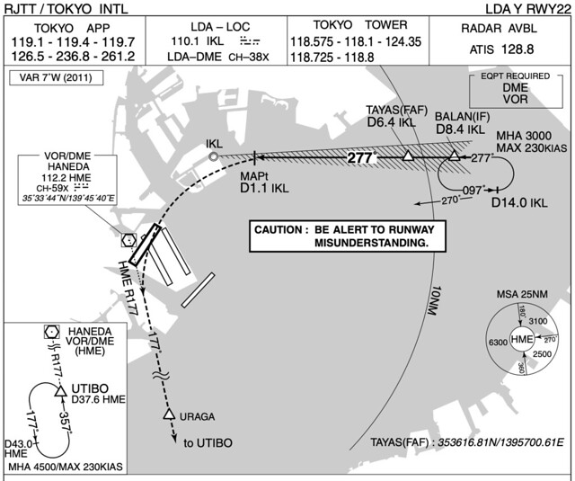
Scenery Before and After Landing at Runway 22 at Haneda Airport
Back from a business trip, landing at Runway 22 at Haneda Airport, sitting on the right side window, I took a few commemorative photos with my RX100 to share with you.
Actually, this flight should have been an LDA X RWY22 Approach,
but for ease of terrain reference, I am using the LDA Y RWY22 approach chart for reference.
Near the outside of the Intermediate Fix IF BALAN
 This waterfront area is the Kaihin Makuhari district.
The Chiba Red Bull Air Race World Championship introduced a few years ago was held here.
The circular building on the left of the photo is Chiba Marine Stadium.
This waterfront area is the Kaihin Makuhari district.
The Chiba Red Bull Air Race World Championship introduced a few years ago was held here.
The circular building on the left of the photo is Chiba Marine Stadium.
Chiba Marine Stadium is one of the main baseball stadiums for Japanese professional baseball. It was completed and opened in 1990 and is currently the home of the Chiba Lotte Marines. This is an artificial turf stadium and was the center of the 2010 National Sports Festival, used to host the opening ceremony.
Near the Final Approach Fix FAF TAYAS, right below are the famous Tokyo DisneySea and Tokyo Disneyland.

A panoramic view of the Tokyo Disney man-made island; the hotel area is on the left, Tokyo Disneyland is in the center of the island, and Tokyo DisneySea is on the right.
 In ANA Tokyo Haneda-Beijing NH961 Flight Trip Report Part 1, I shared photos of Disney during takeoff; you can compare them.
MAPt D1.1 IKT, the point on the chart where the turn begins
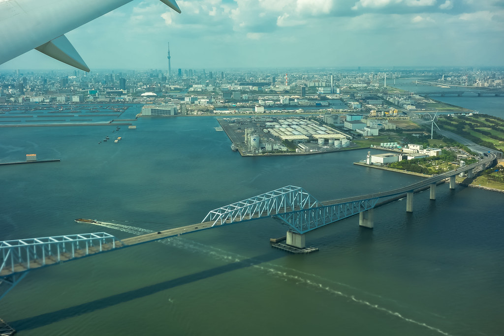
 In the center of the photo is the mouth of the “Arakawa”, and on the right is the sandbar of Kasai Rinkai Park.
The Arakawa is located in the Kanto region of Japan, flowing through Saitama Prefecture and Tokyo Metropolis, among others. The main stream is 173 km long with a drainage area of about 2,940 square kilometers. It is the main stream of the Arakawa river system, designated as a "Class 1 River System" by the Japanese government, and is also a Class 1 River managed by the government, making it one of the important waterways in the Tokyo metropolitan area. Among them, the river section near Onaribashi in Konosu City, Saitama Prefecture, has a river width of 2.5 kilometers, the widest in Japan.
Below is Wakasu Seaside Park, and on the right is the mouth of the “Arakawa”,
In the distance on the left, you can see the Tokyo Skytree, the tallest building in Japan.
Flight altitude 1000 feet.

Near IKL, below is the famous Tokyo Gate Bridge
Turning from west to south, you can see the artificial island below, Odaiba, as well as the high-rise buildings in Tokyo.

 These two are basically continuous shots; you can see the different positions of the ailerons up and down,
indicating that the aircraft is constantly changing its roll attitude.
These two are basically continuous shots; you can see the different positions of the ailerons up and down,
indicating that the aircraft is constantly changing its roll attitude.
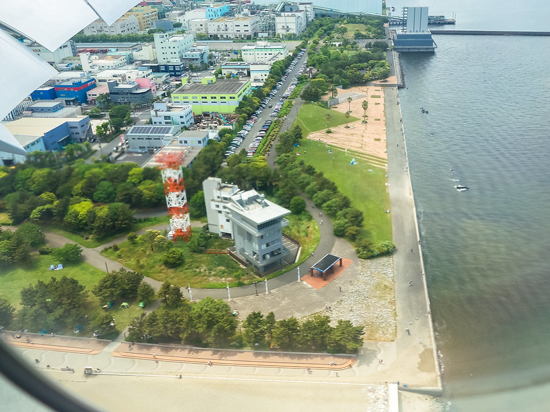
About to land, the plane flares, and right below is the famous spot for plane spotting, Jonanjima Seaside Park.

The moment before landing, the green strip ahead is Keihinjima Tsubasa Park,
 I haven’t been to this park for over 5 years; I need to find time to visit it again in the future.
After landing, the plane taxis out of B4,
 enters U4,
 and then taxis directly to parking spot 148.
 When the visibility is good, Mt. Fuji can be seen from this location,
but in early summer, such weather conditions are a matter of luck.
When the visibility is good, Mt. Fuji can be seen from this location,
but in early summer, such weather conditions are a matter of luck.
By the way, if you are familiar with Haneda Airport, seeing parking spot 148, you can guess which flight I took, right?
LDA X RWY22 Approach
