Aviation Weather
-
Super Typhoon Faxai Hits Tokyo Area
Typhoon Faxai hit with incredible force in the middle of the night; it was likely the strongest storm I’ve ever experienced. I spent the whole night worrying that the window glass might shatter. The power went out for about a minute at one point, but fortunately, it came back on quickly. With the JR lines suspended entirely, I worked from home this morning. Before starting work, here is a quick summary of the airport weather conditions.
-
Okinawa under Super Typhoon Trami
Last time, the attack of Super Typhoon Jebi caused the closure of Kansai Airport and significant damage. Therefore, let’s also pay attention to today’s Super Typhoon Trami, and take a look at the dry NOTAMs and meteorological data.
First, let’s look at the NOTAMs for Naha Airport in Okinawa. The airport is closed, ATC is only providing remote services, and Tower personnel have been evacuated for safety.
4050⁄18 FROM 18/09/28 22:50 TO 18/09/29 21:00 E)ABN-U/S DUE TO TYPH
4049⁄18 FROM 18/09/28 22:33 TO 18/09/29 14:00 E)TWR-CLSD DUE TO TYPH EVACUATION RMK/(1)ATC SERVICE IS AVBL (2)AVBL TWR FREQ 118.1MHZ 308.6MHZ 121.5MHZ 243.0MHZ
-
Kansai Airport in a Super Typhoon
Updated September 5, 2018 Starting at 6 AM this morning, thousands of passengers stranded at Kansai International Airport can take ferries to Kobe Airport, which was largely unaffected by the disaster. Each ferry carries 110 people, with departures every 15-20 minutes. Checking NOTAMs revealed that nearby Kobe Airport and Osaka Itami Airport were not significantly affected by the typhoon and may be able to absorb some of the passenger traffic from Kansai Airport. Media reports suggest that it may take six months to fully restore the road and rail bridge to its pre-accident capacity, but airport flights are expected to resume within a week. By 8 AM, passenger transport via buses across the road bridge had begun. By 11 PM, the airport operator officially announced that all 7,800 people stranded at the airport had been evacuated (except for 25 people who wished to continue waiting at the airport).
-
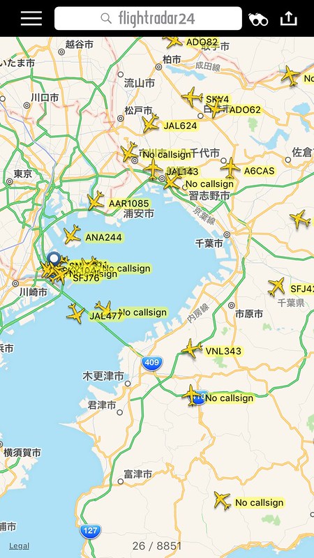
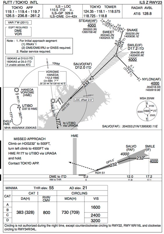
HND ILS RWY22 and RWY23 in Winter Low Pressure
Last summer, I wrote about the rare operation of ILS RWY22 and RWY23 at Haneda Airport. Today, a strong low-pressure system sweeping across the Sea of Japan brought fierce southerly winds, giving it the feel of a small typhoon.
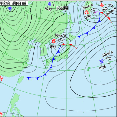
Checking flightradar24 this morning, I noticed that the ILS for Runways 22 and 23 at Haneda had been activated again, with Departures using 16L and 16R.
The chart is as follows:
-
Damage to Yonaguni VOR by Typhoon No. 21
Yonaguni Island, located at the westernmost tip of the Yaeyama Islands in the Ryukyu Islands, is the westernmost island of Japan, only 111 kilometers away from Su’ao Port in Yilan, Taiwan, and is also the foreign island closest to the main island of Taiwan.
Yesterday, Typhoon No. 21 hit Okinawa, Japan, and Taiwan. According to the announcement by the Japan Meteorological Agency, Yonaguni Island recorded a gust of 81.1 meters per second at 15:41, marking the fourth strongest record in Japanese history.
-
Rare Usage of ILS RWY22 and RWY23 at Haneda Airport
During summer seasons with frequent southerly winds, landings at Haneda Airport typically utilize the LDA Runway 22 and Runway 23 approaches. Essentially, to minimize ground noise, aircraft make a wide turn over Tokyo Bay. However, under adverse weather conditions, ILS Runway 22 and Runway 23 procedures are still available. The difference is that aircraft cannot execute turns within the confines of Tokyo Bay; instead, they must queue up early over the northeastern part of Tokyo city.
-
Eruption of Kuchinoerabujima Volcano
At 09:59 on May 29, Mt. Shintake (626 meters) on Kuchinoerabujima Island in Kagoshima Prefecture erupted.
すごい噴火 #噴火 #口永良部島 pic.twitter.com/mzWPhmqHnc
— チクモ (@chikumo3) May 29, 2015I immediately rushed to check the Volcanic Ash Advisory Center website, which I introduced before. The volcanic ash reached an altitude of 32,000 feet / over 9,000 meters; this eruption was indeed powerful. Consequently, the Japan Meteorological Agency raised the volcano alert to the maximum level of 5, requiring all residents on the island to evacuate to safe zones outside the island.
-
Data Formats Issued by Volcanic Ash Advisory Centers: VAAC & VAAT
Volcanic Ash Advisory Center (VAAC)
Volcanic ash clouds often contain large amounts of silicate material, which poses very serious problems for aircraft engines. During flight, the temperature of aircraft engines can reach 800 to 1500 degrees Celsius. When silicate enters the aircraft engine, it can become molten or semi-molten, and stick to the turbine blades in the turbine chamber, obstructing the normal flow of combustion gas. In severe cases, it can even cause the engine to stop (Flameout).
-
Hong Kong Airport Weather during Typhoon VHHH METAR
Yesterday, Typhoon “Usagi” struck Hong Kong. All takeoffs were suspended starting from 6:00 PM, and landings stopped after 7:00 PM. A total of 370 flights were canceled during the day, leaving the Runway in silence. What did the METAR routine aviation weather report look like at this time?
Let’s first look at the weather at 18:00 yesterday:
221100Z 31030KT 7000 -SHRA FEW015 SCT025 27/24 Q0990 TEMPO 3500 SHRAWind speed exceeded 55 km/h, which is indeed quite strong; Visibility was 7 km, moderate; rain showers, but the volume wasn’t heavy; cloud cover wasn’t too extensive; temperature was 27°C, dew point 24°C, indicating extremely high air humidity; pressure was 990 hPa, clearly a low-pressure system.
-
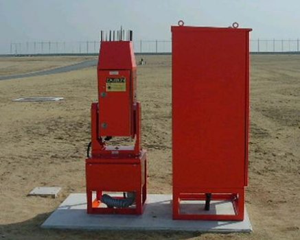
Ceilometer
In aviation meteorology, the Ceiling is a crucial piece of data. Measuring the cloud base height is of great significance for flight safety. This blog previously introduced the restrictions on cloud base height under flight rules in the past article MVFR and LIFR. The article Summary of METAR Aviation Routine Weather Report Format also summarized how to obtain current meteorological data. But how is this data actually measured?
The instrument used to measure this data is called a Ceilometer. In Japanese, it is known as 雲高計(うんこうけい)、雲底計(うんていけい)、雲高測定器(うんこうそくていき), or シーロメータ. In Chinese, it can be translated as 云高仪, 测云仪, 云幂测量仪, 云幂仪, 云幕仪, etc. Its appearance is as follows:
-
What is the Airport ATIS like during a Typhoon?
Yesterday, Typhoon No. 4 was raging. Flight operations are certainly impossible at the airport in such severe weather, but I wondered what the airport’s ATIS broadcast would sound like?
So I tuned the radio receiver to the Haneda ATIS frequency 128.8, and found that the content was indeed drastically different from usual. The wind speed was actually 40 knots, minimum 28 knots, maximum 55 knots! That’s a gale of 100 km/h—terrifying.