Haneda New Approach Route
Three years ago, I introduced future changes to the Arrival and Departure Runways at Haneda Airport, which means that during southerly winds, aircraft will execute an ILS final approach over the center of Tokyo, a significant change from the current approach from the sea.
After several years of preparation, the new routes will be officially implemented starting this March, and test flights have already begun. (By the way, starting March 14, Haneda International Terminal will be renamed to Haneda Terminal 3.)
Now, let’s take a look at the new charts.
RNAV (GNSS) RWY16R (Normal Weather Conditions)

ILS or LOC RWY16R (Severe Weather Conditions)
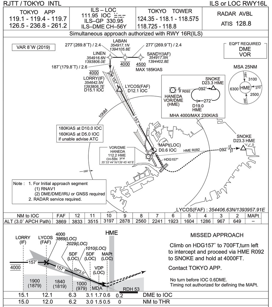
 RNAV (GNSS) RWY16L (Normal Weather Conditions)
 ILS or LOC RWY16L (Severe Weather Conditions)
Looking at dry charts might not give you a real sense of the route, but Japan’s Ministry of Land, Infrastructure, Transport and Tourism has produced detailed explanatory materials, introducing the landmarks passed along the flight path.
For example, when adjusting the Heading to align with Runway 16L,
the aircraft makes a slight turn over Shinjuku Station in Tokyo’s sub-center.
 After that, it passes several stations on the JR Yamanote Line - Ebisu, Meguro, Gotanda, Osaki, and Shinagawa.

The flight altitudes at various landmark stations are as follows: Kita-Akabane: 4000-4500 feet 1200-1350 meters Shinjuku: 3000 feet 900 meters Omotesando: 2500 feet 750 meters Ebisu: 2000 feet 600 meters Osaki, Shinagawa: 1500 feet 450 meters
The media naturally wouldn’t miss the opportunity to cover the test flights.
 As seen in this photo taken from the air above Shinjuku by Kyodo News,
a JAL Boeing 777 has already lowered its landing gear,
flying over the high-rise buildings of central Tokyo.
As seen in this photo taken from the air above Shinjuku by Kyodo News,
a JAL Boeing 777 has already lowered its landing gear,
flying over the high-rise buildings of central Tokyo.
In the photo, the Tokyo Metropolitan Government Building is to the left of the aircraft, with a height of 240 meters, and the aircraft is flying at an altitude of 900 meters. However, due to the shooting angle and the compression effect of the telephoto lens, it looks as if the aircraft is at the same altitude as the building, creating quite a surreal effect.
End