Inside the Cockpit 4.7: Weather and Turbulence
Passengers with flight experience have generally encountered in-air turbulence; it’s certainly not a pleasant experience. This section specifically introduces knowledge regarding weather and turbulence.
Generally speaking, when an aircraft passes through airspace with harsh weather, the airframe will experience vibrations ranging from mild to intense; in severe cases, passengers seated in their seats may be bounced into the air. If one is unlucky, situations may even arise where passengers suffer bone fractures and injuries, or the airframe sustains damage. Even if it doesn’t reach such a level of severity as to cause injury, prolonged turbulence can cause physical discomfort, and more often than not, creates psychological unease for passengers. Therefore, pilots constantly pay attention to avoiding airspace with adverse weather during missions, striving to provide passengers with a safe and comfortable journey. Of course, the structural strength of aircraft is sufficient to cope with turbulence, so there is no issue regarding flight safety.
There are generally several types of turbulence situations; let’s look at them one by one.
First is the Lee wave. The air fluctuations and turbulence formed above the leeward slope of a mountain range are called lee waves. Under static stability conditions, when air is forced to move over a mountain and down the leeward slope, individual air parcels will leave their equilibrium position and perform buoyancy oscillations, forming internal gravity waves on the mountain’s leeward slope. Their formation is related to atmospheric stratification, wind direction, wind speed, and the size and slope of the mountain. When wind speed is high and perpendicular to the ridge, the airflow disturbance is stronger, favoring the formation of lee waves; high and steep mountains can further increase the amplitude of lee waves. When lee waves form, lenticular clouds or wave clouds often appear, running parallel to the ridge and alternating with cloudless areas.
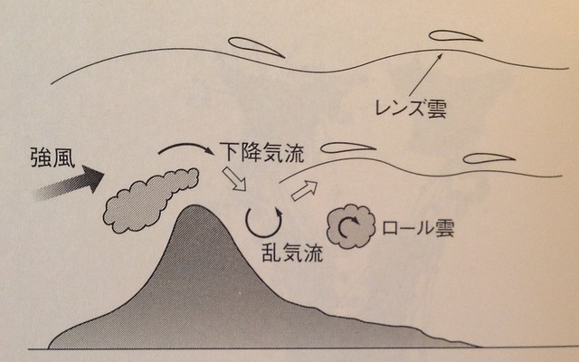
Mount Fuji in Japan is a classic location where lee waves frequently occur. Due to the influence of Mount Fuji’s lee waves, the BOAC Flight 911 disaster occurred. The Boeing 707, registered as G-APFE, was taking off from Japan’s Haneda Airport, preparing to continue its segment to Hong Kong. Shortly after takeoff, it was caught in turbulence, and the airframe strength could not withstand the load, leading to the airframe breaking apart and crashing at the foot of Mount Fuji. All 113 passengers and 11 crew members perished.
Knowing the dangers of lee waves, during the route preparation phase, airlines will divert around prone areas, for example, bypassing the peak of Mount Fuji by passing to the north or south.
The next thing to watch out for is the Tropopause. This is the transition layer between the troposphere and the stratosphere. Its thickness ranges from several hundred meters to 1–2 kilometers, and its altitude varies greatly with latitude and season. Generally speaking, it is higher at the equator than at the poles, higher in summer than in winter, and higher during the day than at night. The tropopause acts like a watershed. Above it is the stratosphere: clear skies, stable airflow, and temperature increases with altitude. Below it is the troposphere: clouds, rain, thunder, and lightning, with myriad changes, and temperature decreases with altitude. Generally, the properties of air determine that warm air is on top (stable) and cold air is on the bottom (unstable). Therefore, the stratosphere is stable, while the troposphere is unstable. The tropopause, situated between the troposphere and the stratosphere, indicates the weather conditions above and below.
Clouds in the troposphere generally stop moving upward when they reach the tropopause. Therefore, the anvil-shaped tops of cumulonimbus clouds are often consistent with the height of the tropopause. Cumulonimbus clouds are very harmful to flight, but by judging the height of the tropopause, one can roughly estimate the possible height of cumulonimbus cloud tops and try to avoid them during flight.
Variations in the height of the tropopause, known as tropopause slope, are also closely related to tropospheric weather. The tropopause above warm air masses is generally higher, while the tropopause above cold air masses is generally lower. A sharp change or even a break in the tropopause height often indicates the presence of high-altitude jet streams and turbulence at a lower level. When an aircraft flies through these areas, it may be significantly affected.
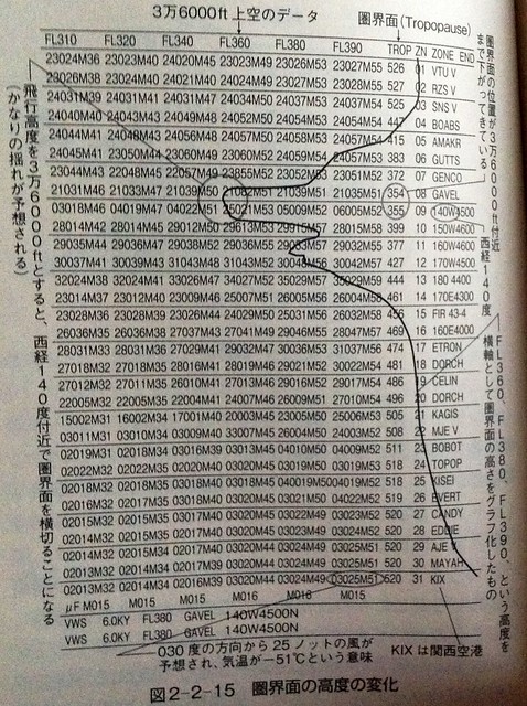
Let’s look at an actual example. In the diagram below, the tropopause height at the GAVEL waypoint drops to 35,400 feet. If the cruising altitude at this time is 36,000 feet, extreme caution must be exercised when flying near 140 degrees West longitude.
Let’s look at this data from another angle,
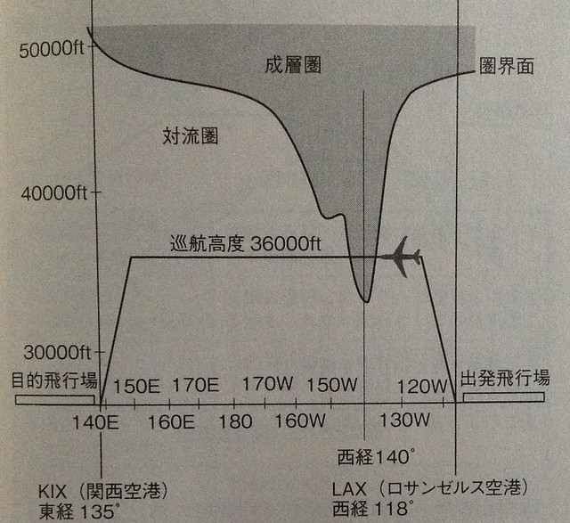 It is easier to understand by looking at the relationship between cruising altitude and tropopause height; the magnitude of the tropopause slope is clear at a glance.
Taking off from Los Angeles International Airport (KLAX) and cruising at 36,000 feet westward, the aircraft will pass through the tropopause when crossing 140 degrees West longitude.
It is easier to understand by looking at the relationship between cruising altitude and tropopause height; the magnitude of the tropopause slope is clear at a glance.
Taking off from Los Angeles International Airport (KLAX) and cruising at 36,000 feet westward, the aircraft will pass through the tropopause when crossing 140 degrees West longitude.
Next, let’s introduce the airborne radar.
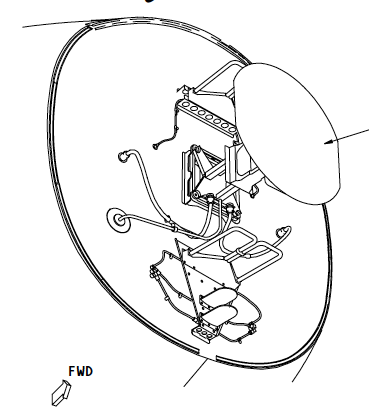
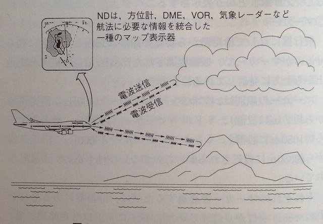
Modern airliners are equipped with weather radar that can provide pilots with meteorological information on the flight path and in the surrounding airspace. As shown in the figure below, the airborne weather radar antenna is located inside the radome at the nose of the aircraft.
 Utilizing the principle that electromagnetic waves radiated by an antenna are reflected back when encountering obstacles, the higher the conductivity coefficient of the target and the larger the reflecting surface, the stronger the echo.
The radar can detect the presence and distribution of meteorological targets and other targets along the flight path ahead of the aircraft, displaying the contour of detected targets, as well as the intensity, bearing, and distance of thunderstorm areas on the display.
Utilizing the principle that electromagnetic waves radiated by an antenna are reflected back when encountering obstacles, the higher the conductivity coefficient of the target and the larger the reflecting surface, the stronger the echo.
The radar can detect the presence and distribution of meteorological targets and other targets along the flight path ahead of the aircraft, displaying the contour of detected targets, as well as the intensity, bearing, and distance of thunderstorm areas on the display.
Generally, on the ND (Navigation Display), different colors are used to indicate various weather conditions. For instance, red areas indicate precipitation exceeding 12mm/h, yellow areas indicate precipitation between 4–12mm/h, green indicates precipitation between 1–4mm/h, and purple indicates unstable airflow.
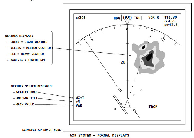
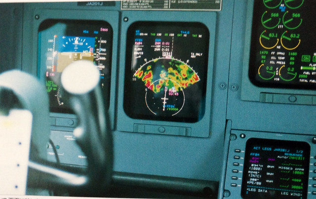 When pilots notice yellow, red, or purple areas in the airspace ahead along the route, they will generally consider taking evasive measures.
Since the situations introduced above can be detected in advance, pilots can bypass these areas during missions. However, there is another type of turbulence—Clear Air Turbulence (CAT)—which has no prior warning, occurs in cloudless conditions where radar cannot detect it, and happens suddenly.
Clear Air Turbulence is relatively likely to appear to the northeast of a low-pressure system experiencing rapid development accompanied by the jet stream.
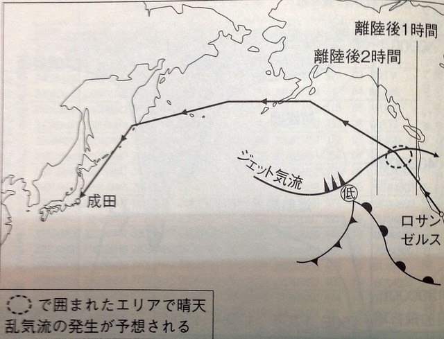 For example, in the diagram above, the area where CAT might occur is outlined with dashed lines. It is predicted that the aircraft will pass through this airspace about 1.5 hours after taking off from Los Angeles. However, since the route cannot bypass this point, when passing through this airspace, pilots will turn on the seatbelt sign, and in-flight cabin service times will be scheduled to avoid this period to ensure the safety of passengers and crew.
Finally, let’s introduce the operations when pilots change the route. First, the Captain and the First Officer investigate the new route. For example, if the original route had waypoints A, B, C, and D, and turbulence occurred near point B, a decision is made to bypass point B and pass via point E, which is tens of kilometers away. However, this change requires permission from ATC. After receiving the pilot’s application, ATC needs to check if there are other flights passing through point E at the same altitude, so obtaining formal permission requires waiting some time. Meanwhile, the aircraft itself is flying at high speed (nearly 900 km/h). If the aircraft has already passed point A significantly by the time permission is granted, it may require a high-angle steep turn to fly towards point E. Such roller-coaster-like flying is certainly not a comfortable experience for passengers, so pilots must pay close attention, constantly monitor the radar display, obtain permission as early as possible when needed, and input the route information into the Flight Management Computer (FMC) as quickly as possible.
To obtain various in-flight weather intelligence, communicating with pilots of other aircraft flying in the same airspace is also very important. Pilots use a special frequency, 123.45 MHz. Because this frequency is dedicated to pilot-to-pilot communication regardless of nationality or airline. For instance, among several aircraft flying in the same direction, if the lead aircraft encounters turbulence, that pilot will notify the following aircraft via this frequency. Consequently, the pilots of the following aircraft will turn on the seatbelt sign in advance to remind passengers to pay attention to turbulence, thereby improving flight safety.
In addition, this frequency is not only used for turbulence but can also be utilized for other emergencies. For example, if a passenger on a certain aircraft suffers a sudden illness and there is no doctor on that plane, the pilot can call for other aircraft on this frequency. If there is a doctor on board, they can help provide emergency medical aid to the patient.
Prev: About Fuel Consumption and Center of Gravity TOC: Table of Contents Next: About Weather and Turbulence (Continued)
End