Airliner Cockpit Secrets 1.3 Pre-flight Briefing
In 1.1 Pilot’s Work Schedule, it was introduced that pilots must report for duty 1.5 hours before departure time.
After reporting to the company, they must hold a Dispatcher Briefing for the flight, which takes place in the flight dispatch office of the company’s flight management department.
Because the pairing of the captain and first officer varies for each flight, they only meet and begin preparations together at this briefing.
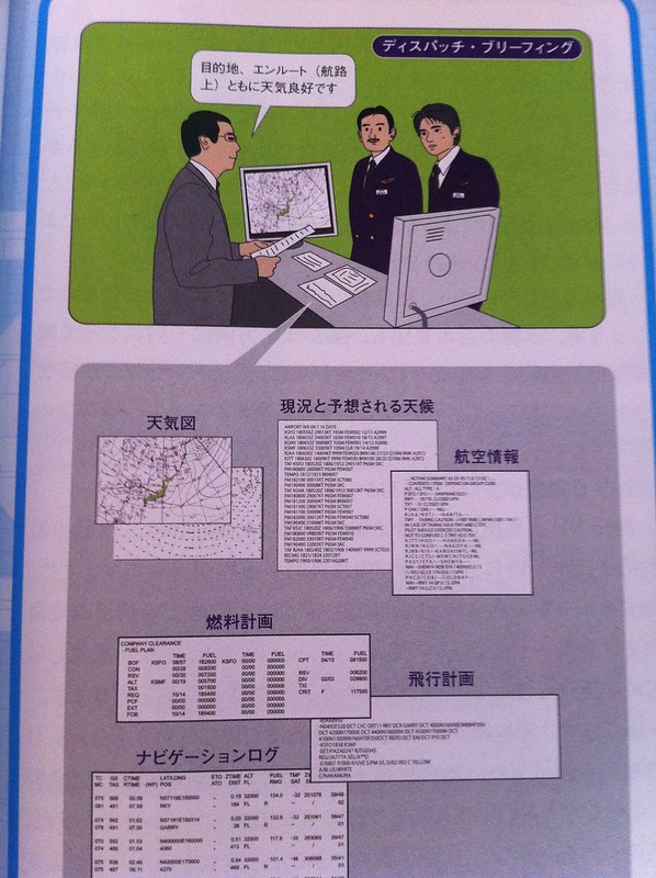
The relevant flight documents for this flight have already been prepared by the flight dispatcher (the staff member on the left in the image above). Regarding the flight dispatcher, the definition in Baidu Baike is quite good, so I’ll just copy it here, sorry about that: “A dispatcher is an indispensable personnel in an airline. Their main job is to collect flight information, formulate and apply for flight plans, and jointly release every flight with the captain. It is a very important role; they can delay, deploy, or even cancel flights based on the situation. Every flight requires a dispatcher’s signature to be released. They must also provide the flight crew with the corresponding Flight Plan (FPL), Aviation Routine Weather Report (METAR), and Terminal Aerodrome Forecast (TAF), Notices to Airmen (NOTAM), and be responsible for their accuracy and for the released flights.”
The flight management departments of major companies like All Nippon Airways and Japan Airlines are located in Tokyo. For flights Departure from Haneda, the briefings can be held at the headquarters. But what about other places? In fact, the flight plans prepared by the dispatchers at the headquarters will be sent to airports nationwide, and the personnel in charge at the local airport offices will explain these plans to the pilots.
The specific contents of the Dispatcher Briefing are as follows, mainly divided into several aspects: weather, NOTAM, routes, and flight plans.
First, pilots must check the weather. As for weather maps, just like the weather forecasts on CCTV, where there are thunderstorms and rain, where it is sunny, the wind direction and force, the air pressure, the movement of cloud charts, etc., ordinary people must be quite familiar with them. The importance of this information to aviation is self-evident; flights will of course be arranged to stay as far away from thunderstorm areas as possible.
But this is not enough; more professional information is needed here.
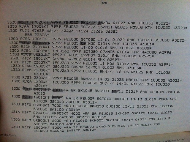 The above shows the current weather conditions (METAR) for various airports,
For example, the first line “1330 RJTT 17020KT 9999 FEW030 BKN/// …”
1330 is the time 13:30. Here, it is in Coordinated Universal Time (UTC), which converts to 22:30 Tokyo time.
RJTT is the code for Tokyo International Airport,也就是 Haneda Airport.
17020KT is the wind direction and wind speed. 170 refers to the direction of 170 degrees. 0 degrees is due north, 90 degrees is due east, 180 degrees is due south, and 270 degrees is due west. So a 170-degree wind is basically a southerly wind. 20KT means a wind speed of 20 knots.
The 9999 item refers to Visibility, in meters. 9999 means greater than 10 kilometers.
FEW030 refers to cloud cover and Ceiling. FEW means few clouds, at an altitude of 3000 feet. Other markers for cloud cover include SCT (scattered), BKN (broken), OVC (overcast), and so on.
The above shows the current weather conditions (METAR) for various airports,
For example, the first line “1330 RJTT 17020KT 9999 FEW030 BKN/// …”
1330 is the time 13:30. Here, it is in Coordinated Universal Time (UTC), which converts to 22:30 Tokyo time.
RJTT is the code for Tokyo International Airport,也就是 Haneda Airport.
17020KT is the wind direction and wind speed. 170 refers to the direction of 170 degrees. 0 degrees is due north, 90 degrees is due east, 180 degrees is due south, and 270 degrees is due west. So a 170-degree wind is basically a southerly wind. 20KT means a wind speed of 20 knots.
The 9999 item refers to Visibility, in meters. 9999 means greater than 10 kilometers.
FEW030 refers to cloud cover and Ceiling. FEW means few clouds, at an altitude of 3000 feet. Other markers for cloud cover include SCT (scattered), BKN (broken), OVC (overcast), and so on.
If you want to know more details about METAR, you can refer to my article Summary of METAR Aviation Routine Weather Report Format.
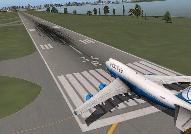
The wind direction at the airport determines which Runway to use for takeoff and landing, because during takeoff and landing, aircraft prefer a headwind. This is because it increases the aircraft’s Lift and reduces the taxiing distance, achieving the goal of safety and saving time and fuel. For example, if taking off with a tailwind, and the aircraft reaches the end of the runway without gaining enough Lift to take off, it will overrun the runway and cause a major accident. Taking off and landing to the south versus to the north results in different flight distances, different flight times, and of course, different fuel requirements.
Runway names are numbered, such as Runway 34, which refers to the direction. For example, the 16L/34R at Haneda below,
points to a magnetic bearing of 337 degrees, which is north-northwest. Because runway numbers have two digits, it is rounded to 34.
R stands for right. Because Haneda has two Runway 34s, the one on the right is 34R, and the one on the left is 34L.
A runway has two ends. The end pointing north is Runway 34, and the end pointing south is Runway 16.
 For example, if the wind at RJTT Haneda Airport above is 17020KT (south wind), then the airport air traffic control will choose to use Runway 16 for takeoff.
What determines the direction of an airport’s runways? This is calculated from the statistical data of the most frequent wind directions at that airport throughout the year.
Before building an airport, several years must be spent observing the wind direction and speed in the area, and the distribution of wind direction and speed is made into a wind rose plot and wind speed rose plot.
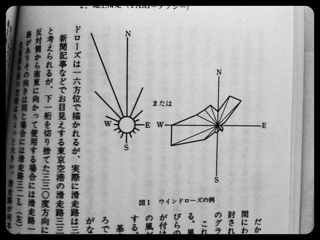 In the polar coordinate system of the wind rose plot, the length of each section indicates the frequency of that wind direction occurring. The longest section indicates the highest frequency of occurrence for that wind direction.
Wind rose plots are usually divided into 16 directions, and some are further subdivided into 32 directions.
Therefore, runways will be built according to the direction with the highest frequency of wind occurrence.
In the polar coordinate system of the wind rose plot, the length of each section indicates the frequency of that wind direction occurring. The longest section indicates the highest frequency of occurrence for that wind direction.
Wind rose plots are usually divided into 16 directions, and some are further subdivided into 32 directions.
Therefore, runways will be built according to the direction with the highest frequency of wind occurrence.
NOTAM information will also be provided to pilots, which refers to temporary regulations, special arrangements, and other information for various airspace and airports. For example, if a certain Runway at an airport is under construction, an air show will be held in a certain airspace, ground navigation equipment is malfunctioning, or there are military activities, etc. NOTAM is the abbreviation for Notice To Airmen. It has a specific unified format, which I will not detail here.
After deciding on the takeoff and landing runways, the entire route can be arranged according to the standard departure and arrival routes of each airport.
At this time, you also need to look at the high-level wind chart below.

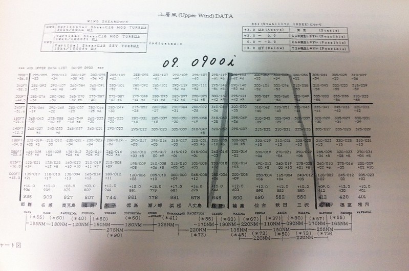 This chart indicates the wind direction and wind force information for various regions at various altitudes.
Especially Clear-Air Turbulence (CAT), which will cause the aircraft to experience bumps,
making passengers uncomfortable, and in severe cases, even threatening flight safety.
Pilots pay great attention to these data. In the image above, the captain has highlighted the areas of concern with a highlighter,
and will try to avoid these areas when choosing the cruise altitude of the flight, providing passengers with a stable and safe journey.
This chart indicates the wind direction and wind force information for various regions at various altitudes.
Especially Clear-Air Turbulence (CAT), which will cause the aircraft to experience bumps,
making passengers uncomfortable, and in severe cases, even threatening flight safety.
Pilots pay great attention to these data. In the image above, the captain has highlighted the areas of concern with a highlighter,
and will try to avoid these areas when choosing the cruise altitude of the flight, providing passengers with a stable and safe journey.
After reviewing the weather, take a look at the flight plan prepared by the dispatcher. First is the COMPANY CLEARANCE.
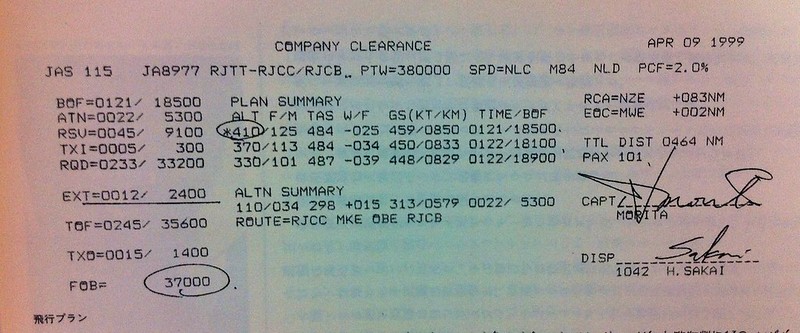 The information here is very important and interesting. It is necessary to explain each item in detail.
JAS 115 is the flight number, JA8977 is the aircraft registration number, RJTT-RJCC/RJCB are the airport codes. RJTT is the Departure airport Haneda Airport. RJCC is the Destination New Chitose Airport (Sapporo) in Hokkaido. RJCB is Tokachi Airport, the alternate airport, located about 200 kilometers east of Sapporo. If landing at the Destination New Chitose Airport is not permitted, such as due to severe weather, earthquakes, or other abnormal situations, the flight will fly to the previously prepared alternate airport. It should be clear that a diversion is not an emergency landing; it is fully prepared. PTW=3800000 Takeoff weight, in pounds. SPD=NLC M84 NLD SPD is speed. NLC refers to normal Climb speed. M84 refers to a cruise speed of Mach 0.84. NLD refers to normal Descent speed. PCF=2.0% performance correction factor. This is the performance correction factor for the flight.
In the middle is the summary of the flight plan. The PLAN SUMMARY consists of the following items: ALT F/M Flight altitude data, providing both imperial and metric figures. F stands for imperial (Feet), and M stands for metric (Meters). TAS W/F TAS at this altitude is True Air Speed. W/F is Wind Factor. If it is a tailwind, it is positive; if it is a headwind, it is negative. GS(KT/KM) Ground speed at this altitude, which is the speed relative to the ground. It is also represented using both imperial and metric data. TIME/BOF The total time and fuel required for the entire journey when flying at this altitude. We can see that the flight dispatcher has prepared 3 sets of flight altitude plans for the captain to choose from. The specific data is as follows:
- At an altitude of 41000 feet / 12500 meters, the TAS is 484 knots, the wind speed at this altitude is a headwind of 25 knots, the estimated ground speed is 459 knots / hour (about 850 km/h), the required time is 1 hour 21 minutes, and the required fuel is 18500 pounds. You can see the *410 mark. The * indicates that this altitude is recommended by the flight dispatcher.
- At an altitude of 37000 feet / 11300 meters, the TAS is 484 knots, the wind speed at this altitude is a headwind of 34 knots, the estimated ground speed is 450 knots / hour (about 833 km/h), the required time is 1 hour 22 minutes, and the required fuel is 18100 pounds.
- At an altitude of 33000 feet / 10100 meters, the TAS is 487 knots, the wind speed at this altitude is a headwind of 39 knots, the estimated ground speed is 448 knots / hour (about 829 km/h), the required time is 1 hour 22 minutes, and the required fuel is 18900 pounds.
ALTN SUMMARY is the flight summary for the alternate airport, in the same format as above. 110/034 298 +015 313/0579 0022/5300 At an altitude of 11000 feet / 3400 meters, the TAS is 298 knots, the wind speed at this altitude is a tailwind of 15 knots, the estimated ground speed is 313 knots (about 579 km/h), the required time is 22 minutes, and the required fuel is 5300 pounds. ROUTE=RJCC MKE OBE RJCB The routing for the diversion, from RJCC New Chitose Airport, passing through two waypoints, MKE and OBE, finally arriving at Tokachi Airport RJCB.
The right column is for navigation, route, and passenger information: RCA=NZE+083NM RCA stands for Reaching Cruising Altitude, which means the location upon reaching the cruise altitude is 83 nautical miles after passing the NZE waypoint. This waypoint is located in the Nasu area of Tochigi Prefecture, Japan. EOC=MWE+002NM EOC stands for End of Cruising, which means the location upon completing the cruise and starting the Descent is 2 nautical miles after passing the MWE waypoint. This waypoint is located in Aomori Prefecture. TTL DIST 0464 NM Total distance is 464 nautical miles. PAX 101 PAX is passenger, meaning the number of passengers is 101.
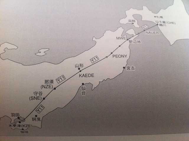
Regarding the MWE and NZE waypoints, as well as the route of this flight, you can refer to the following image.
The left column is the fuel column: BOF=0121/18500 Burn Of Fuel, which is the fuel consumed during the flight. The 1 hour 21 minute flight from Haneda to New Chitose requires 18500 pounds of aviation fuel. ATN=0022/5300 The fuel required to fly from New Chitose Airport to the alternate airport Tokachi, which is 22 minutes requiring 5300 pounds. RSV=0045/9100 Aviation law requires a certain amount of reserve fuel to be carried. RSV stands for Reserved, which means bringing an extra 9100 pounds of fuel that can fly for 45 minutes just in case. TXI=0005/300 This is easy to understand. TAXI means 300 pounds of fuel are prepared for 5 minutes of taxiing on the ground. RQD=0233/33200 The total of the above, which is 2 hours 33 minutes, requiring a total of 33200 pounds of fuel. EXT=0012/2400 This is also reserve fuel. Generally, more is added when the weather is bad, and less when it is sunny. For this flight, it is 12 minutes and 2400 pounds. TOF=0245/35600 Takeoff fuel, the total of the above, which is the fuel load at takeoff. It is 2 hours 45 minutes and 35600 pounds. As you can see, for a flight of 1 hour and 20 minutes, for the safety of passengers, the airline needs to prepare enough fuel to fly twice the time to cope with various emergencies. TXO=0015/1400 Taxi out Fuel, which is the fuel required for taxiing within Haneda Airport from the airport Jet Bridge to takeoff, requiring 1400 pounds for 15 minutes. FOB=37000 Fuel On Board, finally getting the required refueling amount, which is a total of 37000 pounds, requiring about 16.8 tons of aviation fuel!
It can be seen that the captain ultimately agreed to the flight plan at the 41000 feet altitude, which has the shortest route and saves the most fuel, and signed his name in the CAPT section in the lower right corner. At the bottom, the DISP section is for the flight dispatcher’s name.
The flight plan also has a navigation document called the NAVIGATION LOG, which is also very important and interesting, and well worth a detailed analysis.
The image below is the document for the return flight from Hokkaido New Chitose Airport to Haneda Airport:
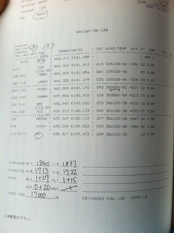
The data format in the NAVIGATION LOG table is as follows: MC AWY WPT PSN COORDINATES DST WIND/TEMP W/F ZT CUM ETO ATO The specific meanings are: MC Magnetic Course, imagine a compass. This refers to the flight direction of this segment. AWY Airway. The airways here are predetermined routes. WPT Waypoint. These are the landmark position points the aircraft will fly over. PSN (FREQ) The position and the radio frequency of the navigation station for the waypoint above. COORDINATES The latitude and longitude of the waypoint. DST Distance, which is the distance between two waypoints. WIND/TEMP The forecast of wind direction, wind force, and temperature. W/F Wind Factor, which indicates whether it is a tailwind or a headwind. ZT Zone Time, which is the time required to pass through this area. CUM Cumulative time from takeoff to this point. ETO Estimated Time of Arrival over the waypoint. ATO Actual Time of Arrival over the waypoint. Pilots need to fill in the actual time here during the flight.
By looking at this table, you can know the exact route the flight will take and how much time the actual flight will require.
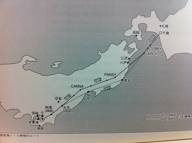
Let’s look at the actual data. First row RJCC #16 N42.471 E141.409 This indicates the starting point of the flight, at RJCC (New Chitose) Airport, Gate 16. The coordinates here are N42.471 latitude, E141.409 longitude. Second row SID CHE(116.90) N42.420 E141.412 015 335038-46 +36 02 0:02 SID stands for Standard Instrument Departure. I will explain SID slowly later; for now, just remember that each airport has specific departure procedures, and pilots must follow the instructions of air traffic control and fly towards the CHE waypoint according to the designated departure procedure route. The frequency of the CHE VOR navigation station is 116.90. Pilots need to set the cockpit navigation instrument frequency to this value to receive navigation information. The latitude and longitude of this waypoint are N42.420 E141.412. DST is 15, meaning the distance from Gate 16 to this waypoint is 15 nautical miles. 335038-46 indicates a wind direction of 335 degrees, basically coming from the north-northwest, with a wind speed of 38 knots, and an air temperature of negative 46 degrees. Because CHE is south of the airport, the 335-degree wind is a tailwind for the aircraft, so the W/F is +36 knots. ZT is 02, meaning it only takes 2 minutes from takeoff to the CHE waypoint. The cumulative time CUM here is of course also 2 minutes. Third row 185 V22 TOBBY N41.551 E141.456 047 335038-46 07 0:09 The flight direction for this segment is 185 degrees, which is basically due south. The airway designation is V22, and the waypoint is TOBBY. The distance from CHE to TOBBY is 47 nautical miles. The wind and temperature are the same as above. The flight time is 7 minutes, and the cumulative flight time is 9 minutes. Fourth row 185 Y10 LARCH N41.302 E141.479 025 335038-46 +35 03 0:12 The flight direction for this segment is still 185 degrees. The airway designation is Y10, and the waypoint is LARCH. The distance from TOBBY to LARCH is 25 nautical miles. The wind and temperature are basically the same as above. The flight time is 3 minutes, and the cumulative flight time is 12 minutes. Fifth row 202 Y10 PANSY N40.002 E141.192 093 300056-52 +21 12 0:24 The flight direction for this segment is 202 degrees, which is south-southwest. The airway designation is Y10, and the waypoint is PANSY. The distance from LARCH to PANSY is 93 nautical miles. The wind direction is 300, the wind speed is 38 knots, the temperature is negative 52 degrees, and the tailwind component is 21 knots. The flight time is 12 minutes, and the cumulative time is 24 minutes. Note the dashed line between the fourth and fifth rows. This line indicates that the aircraft will enter Level Flight cruise during this flight segment, whereas before this, the aircraft was in the Climb phase. Similarly, the line between the fourth-to-last row and the third-to-last row below indicates that the aircraft begins its Descent during this segment. I won’t explain them one by one below; in short, it is a continuous sequence of flight segments leading all the way to the Destination. Last row ILS RJTT #2 N35.327 E139.472 009 306100-38 03 1:09 ILS is the Instrument Landing System, which I will explain in detail later when I get the chance. RJTT is Haneda Airport. #2 indicates that the aircraft will park at Gate 2, and the total flight time will be 1 hour 9 minutes.
Regarding the airways V22 and Y10, as well as the locations of each waypoint, you can refer to the image below.
Combining this image with the navigation log above makes the flight route clear at a glance.
Finally, the items filled in by the captain himself at the bottom of the table are explained in detail as follows: STA=1845 Scheduled Time of Arrival is 18:45. R/I Ramp in, which means the actual time of arriving at the Jet Bridge was 18:40. L/D Landing, which means the actual landing time was 18:37. STD=1715 Scheduled Time of Departure is 17:15. R/O Ramp out, which means the actual time of leaving the Jet Bridge was 17:13. T/O Take off, which means the actual takeoff time was 17:22. ETD= BLX Block time is 1 hour 27 minutes. FLT Flight time is 1 hour 15 minutes. NIT Night flight time is 20 minutes. INST Instrument flight time is 0 minutes. USED FUEL Fuel used was 17000 pounds.
By the way, after this flight plan is officially approved, the dispatcher will submit a flight application to the Civil Aviation Bureau, the government department that manages all flights. When the crew members board the airliner and complete various flight preparations, they will use the radio in the cockpit to confirm with the airport’s departure clearance department that they have received the departure clearance for the flight. Before obtaining clearance via radio communication, the crew members will input the above flight plan into the Flight Management Computer and will faithfully execute the flight mission during the journey.
After arriving at the Destination, the captain fills in the actual flight data on the NAVIGATION LOG form and submits it to the company’s dispatch department. Only then is the entire flight mission officially concluded.
Prev: 1.2 What’s in the Pilot’s Bag? Next: 1.4 Crew Briefing End