A Flight Sim Enthusiast's Notebook
-
What is the Airport ATIS like during a Typhoon?
Yesterday, Typhoon No. 4 was raging. Flight operations are certainly impossible at the airport in such severe weather, but I wondered what the airport’s ATIS broadcast would sound like?
So I tuned the radio receiver to the Haneda ATIS frequency 128.8, and found that the content was indeed drastically different from usual. The wind speed was actually 40 knots, minimum 28 knots, maximum 55 knots! That’s a gale of 100 km/h—terrifying.
-
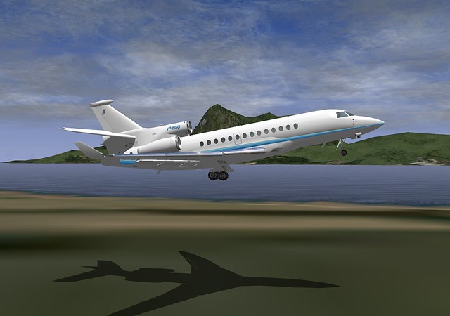
Dassault Falcon 7X Business Jet Freeware Addon
The X-Plane official website introduced a free plugin/addon for the Dassault Falcon 7X business jet. I downloaded and tested it myself; the flying feel is quite nice, so let me introduce it to you.
You need to download it from x-plane.org. If you don’t have an account for this official community website, please register one first. The download link is here.
Installation is very simple. Extract the downloaded zip file to generate the
falcon7X_v9_50orgdirectory, and copy the entire directory toAircraft/General Aviation/in your main X-Plane directory. -
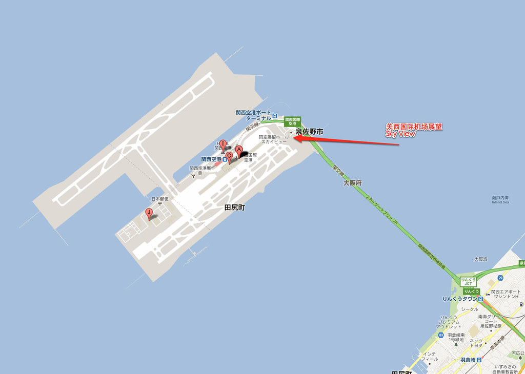
Kansai International Airport (KIX) Photo Diary
Recently, I took the opportunity during a business trip to visit Kansai Airport to watch airplanes.
Why go to Kansai Airport? Because there is a massive observation deck specifically designed for tourists and travelers to observe takeoffs and landings. It’s called Sky View. You can watch various flights up close, and there are facilities like a museum, restaurant, and souvenir shop. It would be a shame to miss it!
Kansai International Airport is located in Izumisano City, Osaka Prefecture, Japan. It serves as the primary international gateway for the Keihanshin (Kyoto-Osaka-Kobe) metropolitan area and the Kansai region. It is situated on an artificial island in Osaka Bay, off the coast of Izumisano, approximately 5 kilometers from the mainland.
-
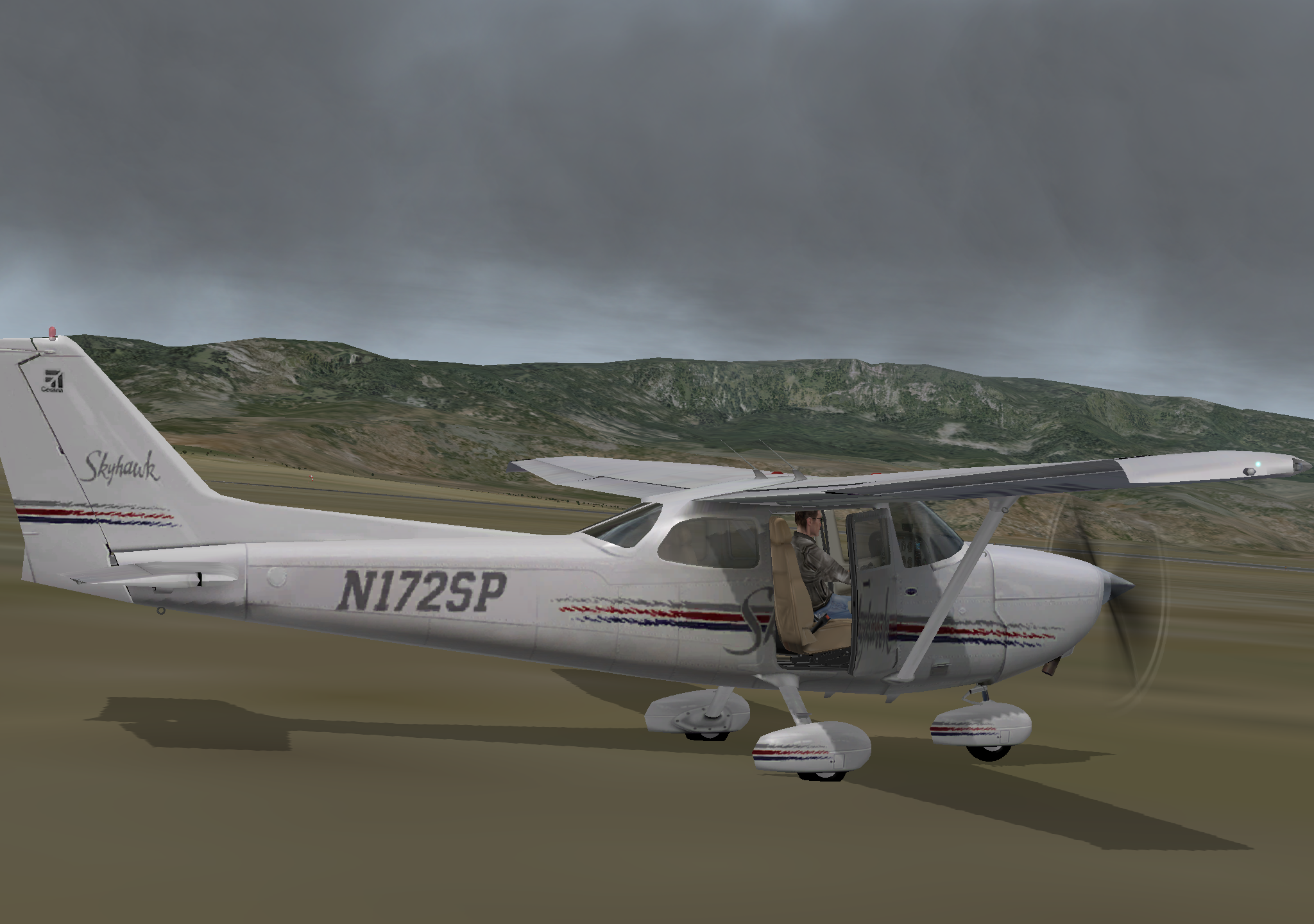
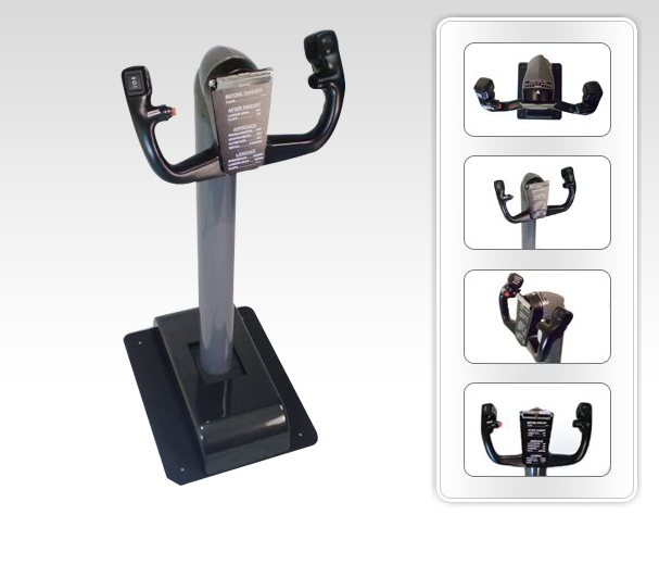
Title: Discover the Amazing Peripheral! 737 YOKE
I’ve always been quite satisfied with my Saitek YOKE; after all, I mainly practice flying small piston-engine aircraft like the Cessna.
But today I discovered an amazing peripheral that I really must introduce to everyone, because its goal is to simulate the control feel of jet airliners. Guess what it is? That’s right, it’s a Boeing airliner yoke!
First, take a look at the photo.
-
Title: A List of ATC Frequencies at Haneda Airport
A Note on Listening to Tokyo International Airport (Haneda) Air Traffic Control (ATC)
Organization of Frequencies and Active Frequencies by Wind Direction at Tokyo International Airport (Haneda Airport).
Writing a note about listening to Haneda Airport Air Traffic Control ATC. Perhaps this article basically has no reference value for friends who don’t live in the Tokyo area, However, I also want to share my experience listening to ATC with everyone through this article, hoping it will be helpful to everyone.
-
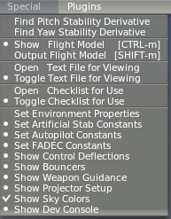
How to Make the Sky Bluer in X-Plane 10? Sky Color Settings
Recently, when running X-Plane 10, I felt the sky color was always gloomy and gray, which was quite uncomfortable. After all, soaring through the air feels best amidst blue skies and white clouds, right? So, I checked the settings and found it’s actually quite simple to modify it back to a blue sky. Below, I will introduce the method.
First, open the Special menu and select the Show Sky Colors option.
-
Notes on ATC Phraseology When Holding on the Ground
1 Hold Position hold position hold position 2 Hold at/of hold of xx hold at xx hold short of xx hold short of xx hold short of runway 34L hold short of Runway 34L 3 Taxi to holding point taxi to holding position xx taxi to holding position xx Note that this means taxi to the position before the Runway, not entering the Runway and holding. 4 Line up and wait line up and wait line up and wait Note that in the past, FAA regulations used the phrase "taxi into position and hold", but reportedly because "hold" was easily misheard as "go" leading to misunderstandings (taking off without waiting), it was changed in the Autumn of 2010 to the international civil aviation standard "Runway 34L, line up and wait". line up basically means to enter the Runway, e.g., line up runway 34L enter Runway 34L 5 Hold from xx hold from xx hold from xx End -
Field Report: Photography at Yao Airport (YAO) in Yao City, Osaka Prefecture
I recently went to Osaka on a business trip and took advantage of my break time to visit a nearby general aviation airport—Yao Airport (YAO Airport)—for some photography. Here is my report. Note: All photos in this article were taken by the author. Reproduction without permission is prohibited.
Yao Airport has the ICAO code RJOY and is located in Yao City, Osaka Prefecture. Yao Airport was founded in 1933 and converted to a military airport in 1939, known as Taisei Airport. In 1952, it was renamed Hanshin Airport, with a portion allocated for civilian use. In 1956, it was renamed Yao Airport, and in 1969, joint civil-military use began. Today, it is utilized by the Japan Self-Defense Forces, newspaper companies, fire departments, police agencies, private enterprises, and individual small aircraft owners. It is famous for general aviation.
-
Title: Real Weather Update Issues
Suddenly noticed that real-world weather wouldn’t update. For flight sim players pursuing realism, this is a major issue. So I checked the forums on the official website, found a workaround that works, and jotted it down immediately.
Actually, the method is very simple, just add one line to the hosts file. 203.167.141.155 weather.noaa.gov Originally, the real-time weather data is located at this URL from the National Oceanic and Atmospheric Administration (NOAA), http://weather.noaa.gov/pub/data/observations/metar/cycles/ but for some reason, the X-Plane program just can’t retrieve it via DNS. So after adding the IP directly to the hosts file, it skips the DNS step, and the data retrieval is successful.
-
Review of ILS Approach and Landing
I basically haven’t touched X-Plane for a week; finally, the weekend is here, so I can have some fun. What should I practice? I realized it’s been a long time since I practiced ILS, so let’s do a quick review.
As always, I’m flying the Cessna 172, taking off from Narita Airport Runway 16L. I checked the weather; there are cloud layers at 3,000 and 8,000 feet. So, I continued a straight Climb along the Runway direction to 13,000 feet. After passing the famous Kujukuri Beach in Chiba Prefecture, I flew west toward the Arlon waypoint.
-
Title: About ATIS Automatic Terminal Information Service
Let’s first copy the introduction from Wikipedia:
“Automatic Terminal Information System (ATIS) is an automatically continuous broadcast information service at busy airports, usually broadcast on a separate radio frequency, including major flight-related information such as weather, active Runway, altimeter setting, and other information. Pilots typically listen to the broadcast before establishing contact with controllers and other units to understand the relevant situation, reducing the workload of controllers and preventing frequency congestion. Under normal circumstances, the broadcast is updated hourly, but can be updated at any time when weather changes rapidly, denoted sequentially by letter codes A, B, C…Z, read using the ICAO published standard letter pronunciation.”
-
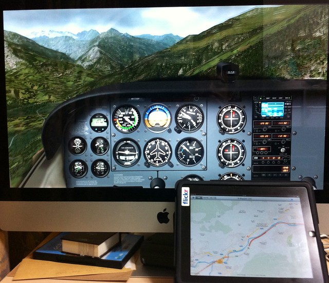
Introduction to X-Mapper: A Convenient X-Plane Map Display App for iPad/iPhone
Today, I’d like to introduce a fantastic free app for iPad/iPhone — X-Mapper. It transmits your aircraft’s real-time geographic position during flight to an iPad or iPhone, letting you view the terrain using iOS’s built-in world map or satellite imagery. The realism is 100%.
The photo below was taken with an iPhone while using an iMac and an iPad simultaneously at home. The flight location is near Briançon, France — the highest town in Europe. The shot was taken flying from the town towards the Alps, and you can even see the snow-capped mountains in the distance. However, flying a Cessna 172 here is definitely a foolish move; shortly after, I flew into the clouds and crashed into a mountain, haha.
-
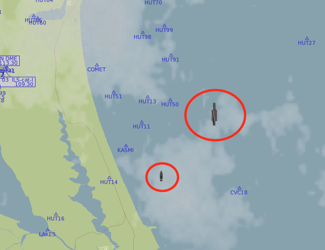
Title: Introduction to khamsin.org
A netizen named pitaFly living in Canada recommended the www.khamsin.org website to me.
I went to check it out immediately and found that this website has developed quite a few stunning Plugins and aircraft for X-Plane, such as the B17 Flying Fortress bomber, offshore oil drilling platforms, the Nimitz-class aircraft carrier, the Perry-class frigate, and so on. They are exquisitely made and are truly worth recommending. In fact, the aircraft carriers and frigates produced by this website are now standard equipment in X-Plane 10; you can fly out to sea to look for them. The method to find them is simple: open the Local Map in the Location menu, move to any sea area, and then look on the map for the icons within the circle in the image below. The large one is the aircraft carrier, and the small one is the frigate. You can generally find them.
 See if you can find them?
If you really can’t find any, you can check if you haven’t selected the item in Settings -> Rendering Options. You can refer to the image below,
See if you can find them?
If you really can’t find any, you can check if you haven’t selected the item in Settings -> Rendering Options. You can refer to the image below,
-thumb-640x480.png) Make sure to check “draw aircraft carriers and frigates”.
Make sure to check “draw aircraft carriers and frigates”. -
Title: X-Plane OpenSceneryX Object Library and Ground Services Plugin
I heard about a Plugin for ground fueling / pushback / passenger boarding stairs, so I looked into it. The results of this Plugin are as follows:
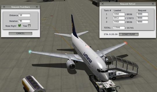
The installation method is as follows: First, you need to install the OpenSceneryX Object Library for X-Plane® Plugin. You can download the installer from the URL below: OpenSceneryX Object Library for X-Plane® For example, select “Mac Installer” for download if you are on Mac, then just start “OpenSceneryX Installer.app”. Because it needs to download a large number of scenery maps from the internet, it takes quite a bit of time; it took me about 1 hour to finish the installation.
-thumb-640x511.png) There are many scenery packages that support OpenSceneryX; here there are scenery maps for hundreds of airports. It seems they are all free—a real treasure trove.
There are many scenery packages that support OpenSceneryX; here there are scenery maps for hundreds of airports. It seems they are all free—a real treasure trove. -
Basic Knowledge of Air Traffic Control (ATC) - 2
Previous: Air Traffic Control (ATC) Basics - 1
-
Title: Air Traffic Control (ATC) Basics - 1
Review Notes: Basic Knowledge of Air Traffic Control (ATC)
I’m writing this review note on basic ATC knowledge for my own future reference and for the benefit of netizens.
First and foremost, practical application is crucial when learning ATC. Buy a radio or wireless receiver capable of receiving the aviation band, check the ATC frequencies for airports near your home online, and there is no secret to it other than listening as much as possible. If you are far from the airport and cannot hear the transmissions for Clearance Delivery, Ground, Tower, Approach, or Departure, don’t worry—even if you can only hear the one-way transmissions between pilots and Center while airborne, you can still achieve the learning objective. I often listen to the Tokyo Control radio communications at home.
-
Munich International Airport EDDM Scenery
Today, the official x-plane.com website recommended a free scenery add-on for Munich International Airport. Since it is free, of course I had to download and check it out.
The download link is here: http://www.x-planes.de/. The product is named “EDDM v2.1 Beta 2”, and the download package name is EDDM_2_1G8B2.zip. It might be a bit tricky to find on the website, so please search patiently.
After downloading, unzip the file to get the EDDM_2_1G8B2 directory. To install, simply copy this directory into the
Custom Sceneryfolder within your main X-Plane 10 directory. -
Introduction to Osaka Itami Airport Photography Spot 1: Senri River
A while back, I went to Osaka on a business trip and used my spare time to visit Osaka Airport to photograph takeoffs and landings. Here is a brief record. Note: All photos in this article were taken by the author. Reproduction without permission is prohibited.
Osaka Airport (RJOO) has always been a place I’ve wanted to visit for photography. That’s because right at the approach end of Runway 32L, there is a small river called the Sengawa River, and there is a walking path along the river. Taking off and landing aircraft fly directly over the walking path. Especially the spot facing the Runway directly, it has become a paradise for aviation enthusiasts. People listening to wireless communications, taking photos, or bringing children to watch the landings—all are shocked by the airliners flying just a few dozen meters above their heads. From the Runway centerline, you can clearly see the pilots making final adjustments to the Attitude (left and right rocking) during landing, or the nose pointing to one side during crosswinds. It is a very rare and excellent place to observe aircraft.
-
Title: Introducing a Free Flight Plan Management Website
I found a flight plan management website http://xplane.anzui.de:3000/flight-planner. It allows you to simply input airports and Waypoints on the map, and save them as an .fms file for use in X-Plane. Since it is free and easy to use, I recommend it to everyone.

-
Opening and Closing the Cabin Door & Flying Over Tahiti
It’s been a while since my last update. I was on a business trip last week, and then went to Kyoto and Osaka to admire the cherry blossoms on the weekend, so I had fewer chances to practice on X-Plane. It’s been raining outside all day today, not suitable for going out, so I’ll just practice properly at home.
I started flying in Hawaii, when I suddenly discovered by chance that the cabin doors of the Cessna 172 can be opened! Just press Alt+E. To close the door, use Alt+R.