A Flight Sim Enthusiast's Notebook
-
Hummingbird Departure Procedure
The names of airport departure procedures are usually named after waypoints, which can sound quite boring. But Tokyo Haneda Airport has a departure procedure with a beautiful name, called the “Hummingbird Departure SID”.
Why am I mentioning this SID? Because a couple of days ago, a relative was on a business trip and sent me this photo via iPhone:
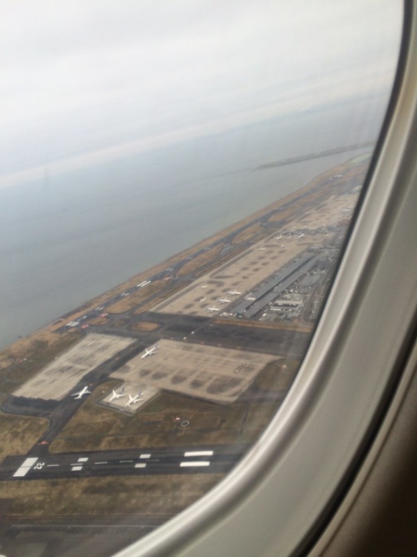 Looking closely, isn’t this the famous Hummingbird Departure procedure? I was quite envious.
 -
New Features of X-Plane 10.50
I received an email from the developers this morning introducing the new features of X-Plane 10.50. Here is a brief introduction.
Regarding static aircraft on the airport, although they increase realism, they sometimes block the Taxiway, and they are not intelligent enough. Therefore, in the new version, airport developers do not need to place static aircraft manually. They only need to configure the settings, and the system will handle everything else.
-
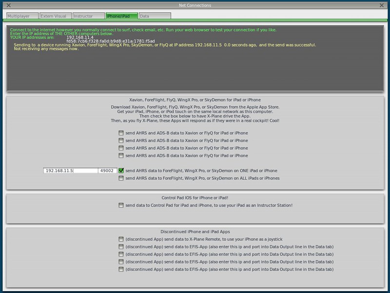
Garmin Pilot now supports X-Plane 10
Garmin Pilot is a renowned iPad app for pilots, offering features such as charts, flight planning, terrain maps, PFD, and ADS-B receiver connectivity. The latest version 8.1, released this month, began supporting X-Plane 10, allowing you to practice using Garmin Pilot at home. Therefore, I installed it immediately and briefly learned how to use it.
The setting in X-Plane is located within Net Connections.
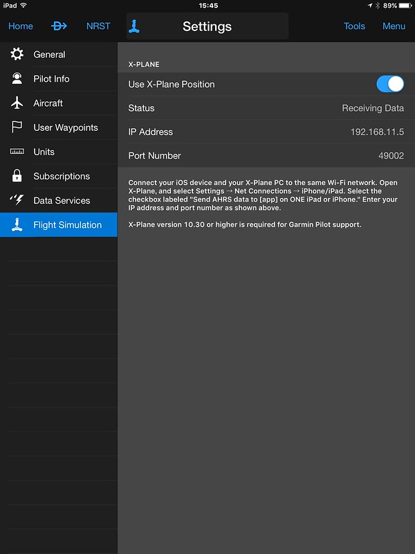
 The setting in the app is as follows; simply turn on “Use X-Plane Position”. It is very simple.
-
CP+ 2016 Camera and Photo Imaging Show
I have been attending the CP+ Camera & Photo Imaging Show every year since 2011, and this marks my 6th time. My thoughts from last year are here – CP+ 2015 Camera & Photo Imaging Show and Aviation Photography Seminar.
I feel that the number of visitors to the venue increases every year. In an era where the economic environment is relatively depressed, the camera market remains quite vibrant, so the CP+ exhibition operation is very successful.

-
X-Life Traffic Plugin
It’s been over a month since I last wrote about X-Plane topics. Today, I’ll briefly introduce this X-Life traffic addon, which was just released recently. This is a product by the renowned JARDesign, and while it is still in the beta stage, it is completely free! Here is its slogan: X-Plane 10 traffic addon Windows / MAC OS 64 bit Plugin by JARDesign Group … You Are Not Alone In The Sky!
-
What is the purpose of the static port on the vertical stabilizer?
This Star Alliance livery ANA Boeing 777 was shot at Tokyo Haneda Airport Terminal 2.

If you look closely at the Vertical Stabilizer, you can see two small white circles on the leading edge.
So, I zoomed in on the photo. Although it’s not very clear, you can still make out the text “Static Port” to the left of the circle,
-
How Much Fuel Is Prepared for a One-Hour Flight?
Another low-pressure day, with persistent rain—perfect for staying in and organizing photos. I found this shot I took a few months ago from the observation deck at Terminal 2 of Haneda Airport. It shows an Obbli ground crew refueling an All Nippon Airways (ANA) Boeing 787-9 for a Tokyo-Osaka flight. On the left, a female pilot is performing a walk-around inspection.
After they finished fueling, I got curious about the actual amount, so I zoomed in with my telephoto lens and got this result:
-
GBAS and GLS
GBAS: Ground-Based Augmentation Systems, a satellite navigation augmentation system where user receivers receive navigation enhancement information from ground transmitters. It consists of three parts: a space navigation satellite constellation system, a ground augmentation system, and an airborne receiver system.
GLS: GBAS Landing System, a satellite landing system based on GBAS navigation performance enhancement. It includes the GBAS system enabling precision approach and landing, as well as related aircraft functions.
The traditional Instrument Landing System (ILS) relies on technology from the 1930s. It provides approach and landing guidance to aircraft through multiple pairs of antennas installed for each Runway, thereby helping aircraft land accurately on airport Runways.
-
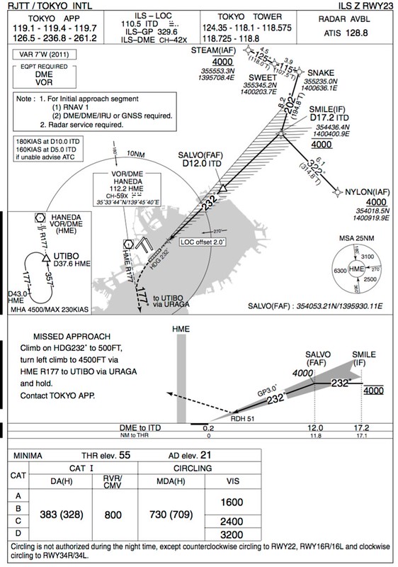
HND ILS RWY22 and RWY23 in Winter Low Pressure
Last summer, I wrote about the rare operation of ILS RWY22 and RWY23 at Haneda Airport. Today, a strong low-pressure system sweeping across the Sea of Japan brought fierce southerly winds, giving it the feel of a small typhoon.
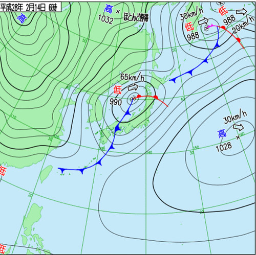
Checking flightradar24 this morning, I noticed that the ILS for Runways 22 and 23 at Haneda had been activated again, with Departures using 16L and 16R.
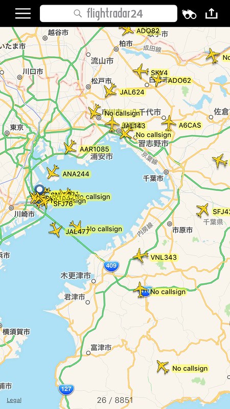
The chart is as follows:
-
Aircraft Photography at Twilight
Generally speaking, the hour or two surrounding sunrise and sunset is the prime time for photography. The light is soft and warm at this time; as sunlight refracts through the atmosphere and projects onto the clouds, it often creates a mysterious aesthetic.
Below are a few photos I took recently. I am particularly fond of these two with Mount Fuji in the background.


-
Unbelievable Korean ATC
I browsed the China Aviation Safety Reporting System SCASS again to check for updates, and saw this incredible <a href=http://scass.hangankeji.com/pcReportShow.action?allreportsId=1139>Hazards Caused by Premature Descent and Transfer of Control, copied below.
The original report is as follows:
-
Visiting ontop, the Aviation Store Claimed to be the Only One in the Kansai Region
Happy Year of the Monkey everyone!
Last week, I went to Osaka on a business trip. Since the meeting ended early, I wasn’t in a rush to go home, so I went to check out the famous aviation goods store Ontop. After all, it’s very close—just take the subway “Osaka Municipal Subway Sakaisuji Line” to “Ebisucho” Station, go out from Exit A1B, and walk north for 2 minutes.
This shop is actually a branch of “Nichiei Wireless,” which sells radio communication equipment. The store is located on the 2nd floor, right above the Nichiei Wireless shop on the 1st floor. However, when I arrived, I found out the owner had stepped out and wouldn’t be back for 40 minutes, so I had to wander around the area. Fortunately, this area is an electronics street with stores like “Joshin Denki,” and since I was already there, I couldn’t just leave without seeing anything.
-
Impact of North Korean Rocket Launches on Civil Aviation
This morning (February 7th), North Korea conducted a satellite launch using a rocket. Let’s take a look at the impact of this event on aviation.
On February 3rd, South Korean authorities issued a NOTAM (Notice to Airmen).
030946 RKRRYNYX (A0170/16 NOTAMN Q)RKRR/QRPCA/IV/NBO/W/000/999/ 3542N12442E030 A)RKRR B)1602072230 C)1602250330 D)2230-0330 E)TEMPO PROHIBITED AREA ACT DUE TO MISSILE LAUNCHING BY DPRK : AREA BOUNDED BY 360400N1243000E-360400N1245400E -351900N1245400E- 351900N1243000E TO THE BEGINNING. RMK : MISSILE DEBRIS WILL FALL IN THIS AREA. F)SFC G)UNL)
-
On the Use of the Chinese Aeronautical Information Publication EAIP
After using the China Aeronautical Information Publication (AIP) website for over a year, they have changed their policy. Now, individuals generally cannot query the latest charts for free, which is a great pity.
However, it seems that data from 2015 is still accessible, for example: eaipchina.cn/Version/201512 www.aipchina.org/Version/201512 Although it is unknown whether these will be taken down in the future, at least for now, everyone can continue to query them for free.
In addition, I found an app for mobile devices called eAPI-China: eAIP-China iOS version, eAIP-China Android version You can also view Chinese charts on it. Although it is not officially offered on the App Store, it seems to allow free queries. Friends with iPhones and iPads can give it a try.
-
Close Call Near Haneda Airport Today?
I saw this message on Twitter, so I looked it up. The ATC communication at the time can be heard on LiveATC, around the 26:30 mark.
However, the audio quality of the file above isn’t great. Since the Tower and TCA (Terminal Control Area) recordings are mixed together, with TCA conversations inserted in between, you cannot hear the entire process clearly.
Here is roughly what happened: Approaching from the north, Lufthansa Flight DLH716 (747-8) was originally scheduled to land on Runway 34R. However, perhaps because 34L is closer to the international terminal, the pilots asked the Tower if they could switch to 34L. It seems the Tower agreed.
-
Website Now Supports HTTPS
Recently, SSL-enabled websites have become the mainstream standard. Since all HTTP communication is encrypted, visitors feel a greater sense of security. Additionally, search engines like Google have started to prioritize HTTPS websites, giving them higher placement in search results.
To keep up with this trend, I have imported an SSL certificate for this site and changed the default access address to HTTPS. Of course, HTTP access remains available as before.
-
GPS Navigation Regulations
I checked the updates to the Japan eAIP and found a new supplement regarding the GPS navigation regulations below:
“AIC Nr 004/16 Operational Standard for the use of GPS when flying under Instrument Flight Rules GPS を計器飛行方式に使用する運航の実施基準”
The content is:
“1-3 Policy for the Use of GPS Because GPS do not fully meet the performance requirements applicable to a sole-means of navigation, they shall be augmented to be used for navigation, if needed.
-
Inexpensive X-Plane External Displays
A few years ago, I introduced a method for X-Plane multi-monitor display settings, which involved connecting multiple computers via a local area network. However, having to boot up two machines every time is quite a hassle, so I generally don’t use this method.
Later, I thought, wouldn’t it be more convenient to connect an iPad to a Mac and use the iPad as an instrument display?
Generally speaking, when using an additional display, the free plugin XHSI is the most common choice; it is very convenient for displaying glass cockpit instruments like the ND. However, since I usually fly small propeller aircraft, I don’t really need such advanced instruments, so there was no need to spend money on a new monitor.
-
Using simbrief.com Maps to Check Routes and Waypoints
I have previously recommended using the most powerful route query tool simbrief.com to query flight routes, Recently, I found that its map function is also very good, providing information such as Waypoints on a single screen.
For example, if you are just looking at the route, skyverctor is indeed sufficient, Looking at the simbrief.com display below, there isn’t a huge advantage,
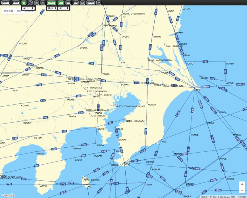 But if you select the AIRWAY point in the toolbar at the top of the screen,
You can immediately see the Waypoints displayed,
But if you select the AIRWAY point in the toolbar at the top of the screen,
You can immediately see the Waypoints displayed, -
Center Main Landing Gear Not Extending
I came across an article online that mentioned there is a landing gear between the left and right main landing gears of the MD-11. This landing gear is generally extended during takeoff and landing. However, when the aircraft is empty, this landing gear does not need to be deployed. The remaining landing gears are sufficient to absorb the impact upon landing, so doing this can reduce tire wear, serving to save on maintenance costs.