Aviation Knowledge Notes
-
Aviation Safety Reporting System ASRS
Let’s start by introducing two terms: the Aviation Safety Reporting System (ASRS) and the Confidential Aviation Safety Reporting System.
The Confidential Aviation Safety Reporting System collects a large number of reports from frontline personnel such as pilots, air traffic controllers, and maintenance personnel. It identifies defects or loopholes in the current civil aviation operation system and serves as primary data for human factors research, helping to improve the civil aviation system and ensure its safe operation.
-
BGAN and Swift Broadband
More and more people are able to access the internet during commercial flights recently. At airports, it is common to see many passenger aircraft equipped with large satellite communication antenna domes on the upper fuselage.
 For example, on the Indonesia Air Boeing 777-300ER above, the one directly above the text “Indonesia” is it; the photo was taken at Narita Airport.
Take another look at this Qatar Airways Airbus A330-200, the photo was taken at Beijing Capital International Airport.
For example, on the Indonesia Air Boeing 777-300ER above, the one directly above the text “Indonesia” is it; the photo was taken at Narita Airport.
Take another look at this Qatar Airways Airbus A330-200, the photo was taken at Beijing Capital International Airport.

-
About Supercooled Water
I first learned about the phenomenon of supercooled water while studying aviation meteorology: Because water lacks condensation nuclei, it can remain in a liquid state even below 0℃. Such water is called supercooled water. When an aircraft flies through a cloud layer containing supercooled water, the supercooled water in the cloud encounters the aircraft and immediately freezes into ice upon contacting condensation nuclei. The aircraft fuselage acts as the condensation nucleus, which alters the aerodynamic shape of the wings. This results in insufficient Lift, making the aircraft prone to accidents.
-
Estimation Formulas - True Airspeed, Descent Rate, Descent Altitude, Cloud Ceiling, and Drift Angle
1. Cloud Base Ceiling Cloud Base (ft) = 4 * (Surface Temperature - Surface Dew Point) * 100 Example: Surface temperature 25°C, dew point 20°C, Cloud Base = 2000 ft 2. Rate of Descent Rate of Descent (ft/min) = Ground Speed * 5 Example: Ground Speed is 140 knots, Rate of Descent is 700 ft/min. 3. Estimating Altitude Based on Distance to Touchdown (3° Descent Angle) Altitude (ft) = Distance (nm) * 300 Example: 5 nm * 300 = 1500 ft. This means when the aircraft is 5 nm from the airport, the altitude should be 1500 ft. 3 nm * 300 = 900 ft, and so on. 4. Track Angle Error TKE Track Angle Error = XTK (Cross-track deviation) * 60 / Distance between two check points For example, if flying 20 nm from A to B, and the cross-track deviation at point B is 2 nm, the Track Angle Error is 6 degrees. The method above is suitable for mental calculation. Of course, if you have a scientific calculator, simply calculating the inverse tangent is easier. For example: tan TKE = XTK / D = 0.1 Therefore, the calculator gives a TKE of 5.7 degrees. 5. True Airspeed and Indicated Airspeed At low to medium altitudes, for every 1000 meters of altitude gained, True Airspeed is approximately 5% higher than Indicated Airspeed. This corrects for the error caused by changes in air pressure. If IAS is 370 and flight altitude is 5000 meters: TAS = 370 + 370 * 5 * 5% = 463 6. Wind Speed Conversion 1 m/s = 1.944 kt ≈ 2 kt Example: A wind speed of 8 m/s is approximately 16 knots. 7. Maximum Drift Angle The Drift Angle is maximum when the Wind Angle (WA) is 90 degrees. DA max ≈ 60 / TAS * Wind Speed Example: True Airspeed 120 knots, Wind Speed 12 knots, Maximum Drift Angle is 6 degrees. 8. Drift Angle DA = DA max * sin WA Example: Magnetic Course (MC) is 90 degrees, TAS is 180 knots, Wind Direction is 135 degrees, Wind Speed is 40 knots. Then DA max = 60 / 180 * 40 = 13 degrees DA = 13 * sin 45 = 13 * 0.7 = 9 degrees 9. Ground Speed GS = TAS + WS * cos WA = TAS + WS * sin (90 - WA) Using the previous example, GS = 180 + cos 45 * 40 = 180 + 0.7 * 40 = 208 knots -
CAAC Officially Releases Electronic Aeronautical Information Publication (eAIP)
Yesterday, I saw the photos of the inaugural flight to Shennongjia Airport posted by a senior pilot. I wanted to create a new airport in X-Plane to simulate takeoffs and landings, but I couldn’t find the airport data anywhere.
However, I accidentally discovered the Electronic Aeronautical Information Publication (eAIP) website officially released by CAAC, which provides access to AIP, AIP AMDT, AIC, SUP, and AIP AMDT download functions.
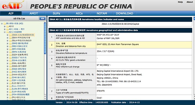
This is great news. I used to painstakingly compile the China AIP myself. From now on, I can just check the eAIP, which will save a lot of time and effort. Thanks a lot.
-
ACARS Message Types
Here, the ACARS message types are listed simply for future reference convenience; there is no additional information. Apologies.
_j No info to transmit. Polled mode ¹ _DEL General response, Demand mode; no information to transmit¹ 00 HJK Emergency situation report 2S Weather request 2U Weather 4M Cargo information 51 Ground GMT request response 52 AGM Ground UTC request 54 Aircrew initiated voice contact request 57 AEP Alternate aircrew initiated posit. rpt. 5D TIS ATIS request 5P Temporary suspension of ACARS 5R AEP Aircraft initiated position report 5U WXR Weather request 5Y ETA Revision to previous ETA 5Z AGM Airline designated downlink 7A ENG Aircraft initiated engine data 7B ABM Aircraft initiated misc.message 80-9 Aircraft addressed downlinks
-
Investigation of ACARS Message Format
I looked up the ACARS data format online and found very limited information. I did manage to find a few helpful links and finally gained a very preliminary understanding of the format. It is too tedious to explain it all here, so I will provide the URLs below; if you are interested, please study them yourself. However, the ACARS message format seems to be customized by each manufacturer. Without internal documentation, it is basically impossible to fully decode it.
-
Methods for Individuals to Receive ACARS Signals
This week, due to the Malaysia Airlines MH370 disappearance (crash) incident, everyone knows that through the ACARS (Aircraft Communications Addressing and Reporting System), the ground can receive a lot of flight data information from the aircraft.
This site has also mentioned ACARS several times in the “Airliner Cockpit Exploration” series, such as Section 1.8 Pre-flight Procedures and Cockpit Interior, Section 2.1 5 Minutes Before Departure, Section 5.1 Descent Preparation, etc. This technology has been quite commonly used in daily airline flights.
-
Useful Information on the Civil Aviation Flight Personnel Management Platform Website pilots.caac.gov.cn
The Flight Standards Office of the Aviation Safety Technical Center of the Civil Aviation Administration of China operates the Civil Aviation Flight Personnel Management Platform website, which contains a lot of excellent materials. Below is a summary of hyperlinks to content of personal interest.
Domestic Pilot Schools (CCAR-141) and Approved Foreign Pilot Schools List of Training Organizations (CCAR-61) Aircraft Type Ratings and Training Requirements Aircraft Pilot, Flight Instructor, and Ground Instructor License Theory Examinations Private Pilot License Theory Examination Syllabus Recommended Aviation Books Extended Reading List Recommended Aviation Books Training Textbooks Recommended Aviation Books General Knowledge
-
Listening to Software Defined Radio (SDR) on a Mac using a Digital TV Dongle and Gqrx -- Listening to the Aviation Band for just a few tens of Yuan
I bought a Mini DVB-T Stick (digital TV stick),
 plugged it into the USB port on my Mac, planning to play with Software Defined Radio (SDR),
The installation process is briefly recorded below.
plugged it into the USB port on my Mac, planning to play with Software Defined Radio (SDR),
The installation process is briefly recorded below.Today I used the open-source software Gqrx on Mac OS, “Gqrx is a software defined radio receiver powered by the GNU Radio SDR framework and the Qt graphical toolkit.” The download address is http://gqrx.dk/download. The latest version of the software is now 2.2.0, so I got the package gqrx-2.2.0.dmg, After decompressing, I got Gqrx.app, and just copied it to the Applications directory.
-
Total Air Temperature TAT Static Air Temperature SAT Outside Air Temperature OAT
There was a discussion on Baidu Tieba regarding this topic, so I looked up some information. The original question was: “Why does the engine information panel display the converted TAT instead of OAT? What exactly are they used for respectively?”
1. Definitions TAT (Total Temperature): Total Air Temperature SAT (Static Air Temperature): Static Air Temperature OAT (Outside Air Temperature): Outside Air Temperature
2. The relationship between TAT and Pressure According to the introduction in Wikipedia, Total Temperature (also known as stagnation temperature or total temperature) is a term related to aerodynamics. A fluid in motion possesses pressure, temperature, density, velocity, and Mach number. If a fluid can be brought to a complete standstill via an adiabatic process, its kinetic energy is converted into internal energy, manifesting as changes in pressure, temperature, and density. The temperature at this moment is the total temperature. A practical example is the aircraft’s pitot tube measuring total temperature and total pressure at its front end.
-
Study Notes on Ground Effect
Content excerpt from FAA-H-8083-25A Pilot’s Handbook
When an aircraft is just leaving the ground or water, compared to a state of level flight at a certain altitude, it can obtain sufficient Lift at a slightly slower speed. This phenomenon is Ground Effect.
When the aircraft is flying at an altitude of several feet from the ground, the airflow patterns in all three axes of the aircraft change because the vertical airflow near the wings is restricted by the ground. Consequently, the upwash, downwash, and wingtip vortices all change. The ground surface obstructs and alters the airflow pattern during flight, which creates Ground Effect.
-
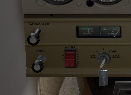
What is Primer?
A friend on Baidu Tieba asked what a Primer is? After answering, I felt this might be a common question, so I decided to write a short note.
Translating “Primer” into Chinese literally means to inject or add. On small propeller aircraft, the Primer refers to the priming pump for engines with a carburetor fuel supply system (also known as a priming pump, primer valve, primer switch, etc.).
-
Propeller Metrics: Pitch and Blade Angle
In the FAA-H-8083-25A Pilot’s Handbook of Aeronautical Knowledge, there is the following explanation:
Propeller Pitch The pitch is defined as the distance a propeller would travel in one revolution if it were turning in a solid.
Blade Angle The angle of a propeller blade, as measured against the hub of the propeller, keeps the angle of attack relatively constant along the span of the propeller blade, reducing or eliminating the possibility of a stall. Blade angle, usually measured in degrees, is the angle between the chord of the blade and the plane of rotation and is measured at a specific point along the length of the blade.
-
The Ultimate Route Planning Tool: simbrief.com
Last week, I registered for a free account on the http://simbrief.com website. After giving it a try, I found that this site can easily be called the most powerful route query tool and dispatch tool in history. I hope everyone will give it a try; the features are truly overwhelmingly powerful.
For example, let’s look at the route query first. After entering a few simple data points like date, aircraft type, airport name, etc., (I didn’t input fuel, so the data is abnormal, please ignore)
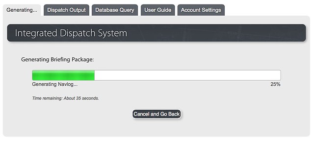 Wait for about a minute,
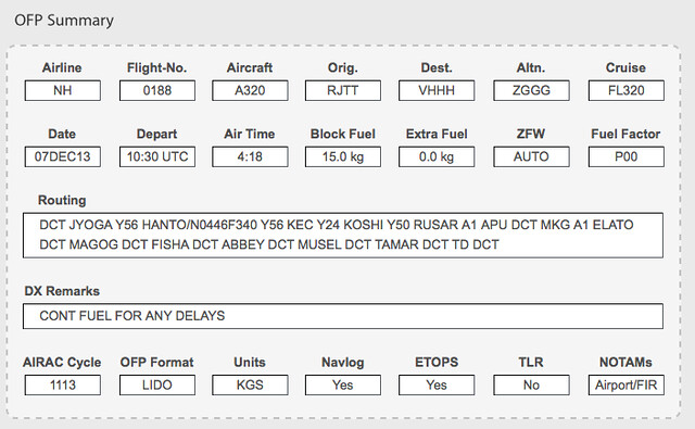 and the Waypoints, alternate airports, and all this information comes out.
 -
Setting Up a Discone Antenna (D130) for Aviation Band ATC Reception
Recently, in order to better receive Air Traffic Control, I spent 12,000 yen (120 USD) to purchase a Discone antenna.
 The results are quite satisfactory, and it has significantly improved radio reception.
This product model is the D130, manufactured by Diamond Antenna Corporation. It is an antenna with a very good reputation among aviation enthusiasts, recommended by many books and magazines. The reception frequency range of this antenna is very broad, covering from 25Hz to 1300MHz. However, the dimensions are large, with a height of 170 cm and a diameter of 84 cm, so it takes up a lot of space once installed. I racked my brains trying to find a place for it; I tried several spots on the balcony but couldn’t find a permanent home for it. Therefore, I temporarily decided to set it up every time I use it and put it away when I’m done.
-
Introduction to Visual Docking Guidance System
As everyone knows, after an aircraft lands, it either docks at the Jet Bridge, requiring ground marshals to visually estimate the distance and guide the pilot by holding up yellow signs; or it uses the Visual Docking Guidance System, where the pilot controls the aircraft to taxi into the parking spot based on the instructions on the display screen ahead.
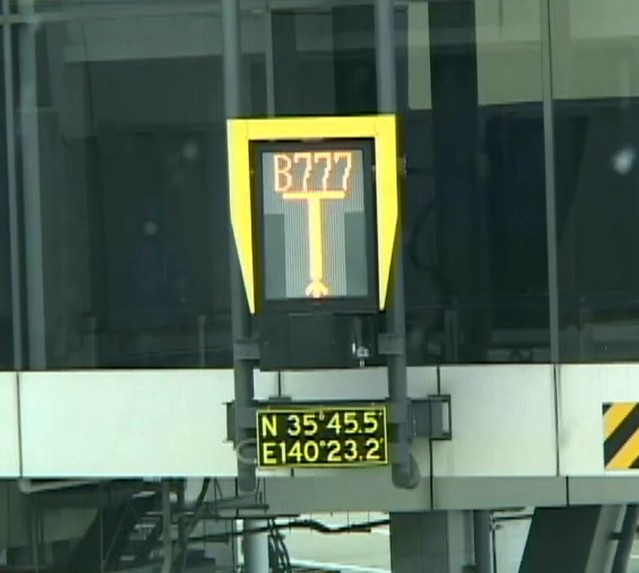
I recently saw the system manual for Haneda Airport and found it quite interesting, so I decided to briefly record it.
-
List of Radio Navigation Facility Channel Numbers and Frequencies TACAN channels number
Each VOR/DME navigational facility uses different frequencies for the VOR and DME components, while a single channel number is used to define the facility. Therefore, knowing the number means you can identify the corresponding frequencies. (This channel number was originally defined by the military TACAN navigation system.)
Additionally, since knowing the VOR frequency allows you to determine the DME frequency, listing only the VOR frequency on en-route charts is sufficient.
-
Weather Map Symbols
I recently read the Chinese version of the FAA Pilot’s Aviation Meteorology. I noticed that there isn’t much explanation about the weather charts themselves, so looking at the various symbols on the charts felt a bit like “viewing flowers in the fog” (puzzling).
After looking it up, I found the Japan Meteorological Agency’s Surface Weather Chart Symbol Explanation to be quite good. It’s hard to memorize all the symbols for cloud amount, cloud type, cloud height, smoke, rain, snow, hail, thunderstorms, etc., at once, so now I can check them whenever I need to.
-
How to Create a VFR Flight Plan
I previously wrote a guide for IFR flying; today, having some free time, I thought I’d write another one, this time on creating a flight plan for Visual Flight Rules (VFR) in a small aircraft.
First, select a flight target. I’ve been on business trips to Osaka quite often recently, so I’m quite familiar with the area. Let’s start from Osaka and do a sightseeing flight. Osaka has a general aviation airport — Yao Airport RJOY — so we will take off from here. For the Destination, let’s choose Tokushima Airport RJOS in the south. This route allows us to pass over the bustling cities of Osaka and Kobe, see the famous Akashi Kaikyo Bridge and Naruto Bridge over the sea, as well as the beautiful natural scenery of Awaji Island. It is perfectly suitable for a sightseeing flight.