Aviation Knowledge Notes
-
Abbreviations for CDM (Collaborative Decision Making) System and Release Usage
There are too many to remember, so just memorize the following few for now. By the way, the Collaborative Decision Making section of the Air Traffic Management Bureau of the Civil Aviation Administration of China website contains many excellent materials with high reference value.
CDM (Collaborative Decision Making) Multi-Airport Departure Clearance Collaborative Decision Making System
STD (Scheduled Time of Departure) Scheduled Door Closing/Opening Time, The flight schedule time approved in the airline’s application
-
EDTO vs ETOPS
Looking back at photos I took before, I noticed that this Asiana A330 has “EDTO” lettering on the fuselage.

I only knew about ETOPS before; it turns out there is also EDTO. Let’s look at their definitions. The source is from the official website of ICAO.
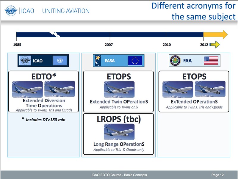 ETOPS and EDTO are different terms for the same thing: "Extended Diversion Time Operations".
ICAO calls it EDTO (Extended Diversion Time Operations), including twin, tri, and quad-engine aircraft.
Europe calls it ETOPS (Extended Twin OPerationS), specifically referring to twin-engine aircraft; for tri and quad engines, they use LROPS (Long Range OPerationS).
The US FAA's ETOPS (ExTended OPerationS) also includes twin, tri, and quad-engine aircraft.
(I remember it used to be called Extended-range Twin-engine Operational Performance Standards; it seems the definition of the name has evolved too.)
ETOPS and EDTO are different terms for the same thing: "Extended Diversion Time Operations".
ICAO calls it EDTO (Extended Diversion Time Operations), including twin, tri, and quad-engine aircraft.
Europe calls it ETOPS (Extended Twin OPerationS), specifically referring to twin-engine aircraft; for tri and quad engines, they use LROPS (Long Range OPerationS).
The US FAA's ETOPS (ExTended OPerationS) also includes twin, tri, and quad-engine aircraft.
(I remember it used to be called Extended-range Twin-engine Operational Performance Standards; it seems the definition of the name has evolved too.)
According to the Advisory Circular of CAAC, Extended Diversion Time Operations refers to an operation where the flight distance from at least one point on the planned route to any optional diversion airport for the extended range operation exceeds the flight distance corresponding to 60 minutes (for aircraft powered by two turbine engines) or 180 minutes (for passenger aircraft powered by more than two turbine engines) at the approved cruising speed with one engine inoperative in a still atmosphere under standard conditions. In this Advisory Circular, Extended Diversion Time Operations, ETOPS (Extended Range Operations), and Extended Diversion Time Operations, EDTO (Extended Diversion Time Operations) are synonymous.
-
Charted Visual Flight Procedure (CVFP) Approach
Kagoshima Airport added a CVFP approach procedure starting in April: KINKO VISUAL RWY34. This is relatively rare. Compared to visual procedures with high flexibility, CVFPs mark clear airways on the approach chart, including visual reference landmarks and other flight altitude information.
Let’s take a look at the details.

First, after passing the ISKID Waypoint in the bottom right corner, the aircraft flies along the coastline, which is the KGE 225-degree radial. The chart shows the reference landmark SAKURAJIMA, the famous island in the sea—Sakurajima. This chart is indeed very clear.
-
When to Engage and Disengage the Autopilot
This is a frequently asked question, or how visitors arrive at this site via search engines, so let’s look at an example. Today, we will use data from the flight manual for a Shanghai Airlines A321, excerpted from sections such as “Minimum Altitude for Autopilot Use,” “Autoland,” and “Category II/III Operations.” You can see that the minimum altitude requirements vary under different conditions.
-
How Does an Airplane Generate Lift? Bernoulli's Principle, Kutta-Joukowski Theorem, Starting Vortex, and Wingtip Vortices
Regarding the principles of flight, specifically the question of where an aircraft’s Lift comes from, most books mention Bernoulli’s Principle. Because the airflow is divided into upper and lower parts at the leading edge of the wing, the airflow speed on the upper surface is faster than that on the lower surface. Consequently, the air pressure on the upper surface is lower than that on the lower surface, and the pressure difference between the upper and lower surfaces generates Lift.
-
VfrFlight: Free Tool for Creating Visual Flight Plans
VfrFlight is a highly recommended tool for creating VFR flight plans. It is not only feature-rich but also free. Because it is written in Java, it works on various computers like Windows/Mac OS/Linux. Other features include: Simple and easy to understand UI, Linked world map, Database of airports / VOR stations / cities, Global Minimum Safe Altitude (MSA) database, Real-time METAR and TAF data, Flight plan output in pdf and html formats (sample) Automatic search and display of nearby VORs, Automatic calculation of Weight and Balance, Automatic calculation of wind correction [NEEDS REVIEW], Automatic calculation of distance, speed, altitude, and flight time and more.
-
Basic Practice of Turns
— Key Points —
Since writing the introduction to slip and skid, I realized it had been a long time since I practiced basic maneuvers. So, I spent a few hours flying turns in the Cessna 172 on X-Plane 10, focusing on my personal weaknesses:
- Adjusting rudder pressure based on attitude to maintain a coordinated Turn, avoiding entering a slip or skid state.
- Maintaining a stable altitude, specifically ensuring no altitude loss.
- Coordinating yoke and rudder operations (using hands and feet simultaneously) with smooth inputs.
- Using external visual references combined with instruments, ensuring the scan doesn’t fixate on a single point.
- Not just following instructions mechanically during flight; be aware of the lift and gravity components during a Turn, and the effects of Thrust, propeller slipstream, P-Factor, and gyroscopic precession on flight attitude.
- Keep the body posture upright; be mindful of unconscious tilting of the body or head.
- Breathe deeply occasionally to relax the shoulders and release tension from the control pressures on hands and feet.
— Entering the Turn —
-
Slip and Skid
It seems that “slip” and “skid” are both translated as 侧滑, so what is the specific difference? Let me try to summarize them.
When watching car racing, you can often see drivers using slipping techniques during turns, intentionally causing the car body to move “sideways” to achieve a quick turn. (Generally speaking, slip refers to oversteering or fishtailing; for example, if the steering wheel is turned 30 degrees, but the car actually turns 40 degrees.)
-
One Meter Pass Notes
I chatted with my senior on Weibo about low-altitude passes; here are my notes.
Overview: An instructor pilots a light aircraft for a pass at 1 meter. (A low-altitude pass refers to an aircraft flying over the airport Runway or over the front of the viewing stand during flight, Source: Baidu Baike)
Objective: To help the student establish the concept and sensation of low-altitude flight, essentially cultivating the flight feel for landing.
-
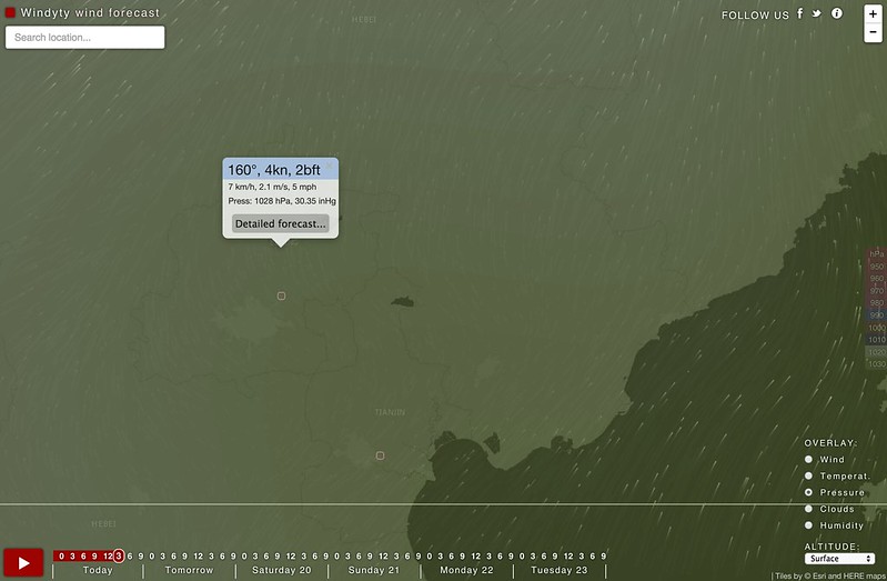
Awesome Weather Site: windyty.com
Typhoon! A typhoon is coming! Which website is good for checking typhoon dynamics and typhoon tracks?
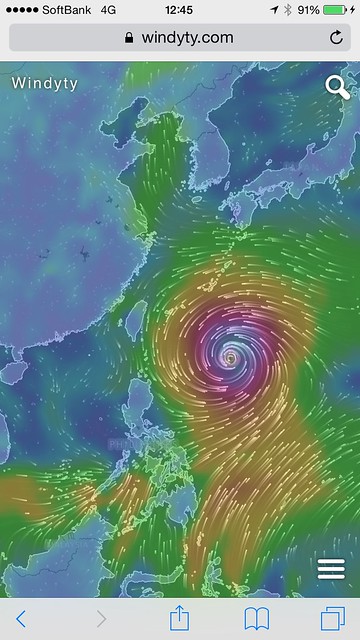
windyty.com weather site uses a Google Maps-style UI to display current global wind direction and speed, temperature, pressure, cloud layers, and humidity information, as well as weather forecasts for the week ahead. This website’s UI is truly excellent; just click on the map to bring up a display box and get meteorological information for that location.
-
METAR Aviation Routine Weather Report during Volcanic Eruption VA
In the METAR, under the OBSCURATION section for flight visibility, there is a definition for volcanic ash, “VA Volcanic Ash” Currently, Mount Aso in Kumamoto, Japan has erupted, and domestic flights across Japan have been grounded.
500RT: [Eruption of Mt. Aso] Volcanic smoke up to 1000 meters above ground; Kumamoto - The Meteorological Agency calls for attention to damage to crops caused by volcanic ash. pic.twitter.com/P6zour8zJ0 https://t.co/441WP8yufq
— 前田洋輔 (@yokohama_77) November 26, 2014As you can see, it is indeed marked.
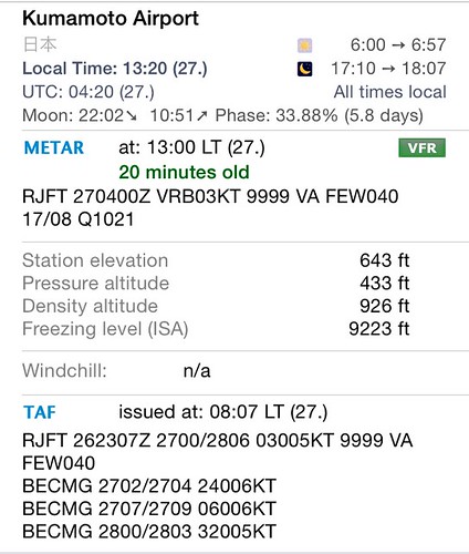 Since this is quite rare, I’m making a note of it.
 -
Converting Meteorological Visibility to CMV
When viewing Japanese aeronautical charts, it is common to see CMV (Converted Meteorological Visibility) used in the Landing Minima. This metric is used when the airport does not have RVR equipment or when the equipment is inoperative. CMV needs to be calculated using METAR or ATIS. The conversion is divided into Day and Night, and takes into account the status of lighting equipment. The CMV value is obtained by multiplying the Meteorological Visibility VIS by a factor.
-
PBN (Performance Based Navigation)
PBN (Performance Based Navigation)
1 PBN Basic Concepts
Performance Based Navigation (PBN) is a new operational concept proposed by the International Civil Aviation Organization (ICAO) based on the integration of regional navigation (RNAV) and required navigation performance (RNP) operational practices and technical standards from various countries. It combines advanced airborne aircraft equipment with satellite navigation and other advanced technologies, covering all flight phases from en-route, terminal areas, to approach and landing, providing a more precise and safe flight method and a more efficient air traffic management model. At the 36th Session of the Assembly in September 2007, ICAO formally required all Contracting States to fully transition from traditional ground-based navigation flight modes to PBN in a globally consistent and coordinated manner by 2016.
-
Aileron Reversal
The following is an excerpt from Baidu:
Due to the elasticity of the wing, the moment generated by the **Aileron** acting on the wing also causes the wing to twist and deform in the direction opposite to the **Aileron** deflection. This changes the wing's Angle of Attack (AOA), thereby generating a moment under the action of aerodynamic forces that opposes the rolling moment produced by the **Aileron**. When the flight speed reaches a certain value, the rolling moment generated by manipulating the **Aileron** and the moment generated by the elastic deformation caused by the aerodynamic forces on the wing cancel each other out, causing the **Aileron** to fail (i.e., the **Aileron** effect is zero), and the aircraft becomes uncontrollable. This flight speed is called the reversal speed. When the flight speed continues to increase and exceeds the reversal speed, the rolling moment generated by manipulating the **Aileron** will be less than the opposing moment generated by the wing deformation under aerodynamic forces. At this time, the **Aileron** effect is negative and plays an opposite role. ---- This situation is referred to as "**Aileron** Reversal".

Methods to solve the **Aileron** reversal problem include first, increasing the torsional stiffness of the wing box. Another method is to move the **Aileron** closer to the wing root, where the wing stiffness is higher. However, during low-speed flight, due to low aerodynamic efficiency, one must still rely on the outer **Aileron**, where the moment arm is long. Therefore, some aircraft are equipped with inner **Aileron**s and outer **Aileron**s. However, because inner **Aileron**s interrupt the **Flaps**, affecting takeoff and landing performance, aircraft with inner **Aileron**s are not common. Modern transport aircraft, in addition to increasing wing torsional stiffness, more frequently use **Spoiler**s to assist **Aileron**s in roll control at high speeds, sharing part of the load of the outer **Aileron**s.
The following is an attempt to summarize the Aileron configurations of common passenger aircraft models.
-
FIS-B and TIS-B
ADS-B ground stations can transmit information to aircraft, which is specifically divided into two categories: Traffic Information Service Broadcast (TIS-B) and Flight Information Services-Broadcast (FIS-B).
TIS-B: The ADS-B ground station receives ADS-B position reports transmitted by aircraft and transfers this data to the Surveillance Data Processing System (SDPS). Simultaneously, the SDPS also receives data from radar and other surveillance equipment. The SDPS fuses this data into unified target position information and sends it to the TIS-B server. The TIS-B server integrates and filters the information to generate a comprehensive air traffic surveillance picture, which is then sent to the aircraft via the ADS-B ground station. This allows the flight crew to obtain complete and clear air traffic information. The application of TIS-B enables users of different ADS-B data link types to obtain surrounding airspace operational information, thereby achieving indirect mutual visibility.
-
Buffet Margin
The buffet boundary is the second most important aerodynamic performance parameter in aircraft design, following the Lift-to-Drag ratio (L/D).
Wing buffet is the random excitation response of the wing structure to pressure pulsations caused by airflow separation. When an aircraft flies at low speeds and high angles of attack, buffet occurs once the airflow separation on the lifting surfaces reaches a certain degree. This type is referred to as lift-type buffet.
-
FPA PA AOA
FPA: flight path angle PA: pitch angle
Pitch angle is the angle between a line through the aircraft’s nose and the horizontal. By convention we call this THETA. This is what we see on the ADI. Flight path angle is the angle between the aircraft’s velocity vector and the horizontal. By convention we call this GAMMA. In the climb pitch attitude is equal to the angle of climb plus angle of attack.
-
Private Pilot License Practical Test Standards PPL
The “Private Pilot License Practical Test Standard DOC NO. FS-PTS-001R1” issued by the Flight Standards Department of the Civil Aviation Administration of China. Those who want to learn to fly can refer to it. The link is here.
-
METAR Format Specifications
Write a simple memo.
Found the METAR format specification by chance on the website of the World Meteorological Organization (WMO). The original document is here; refer to the section on FM 15 METAR. It’s quite dry, so I probably won’t read it from start to finish. Just use it as a manual for looking up unfamiliar codes when you encounter them in the future.
-
Real-time Thunderstorm and Lightning Map Website: Blitzortung.org
For aircraft, thunderstorms and lightning are always the most dangerous natural phenomena; the farther away you can stay, the safer it is. However, finding information on where exactly in the world thunderstorms are located is actually quite difficult. Fortunately, we now have Blitzortung.org, which allows you to view current thunderstorm and lightning activity on a world map. It is truly a great website.
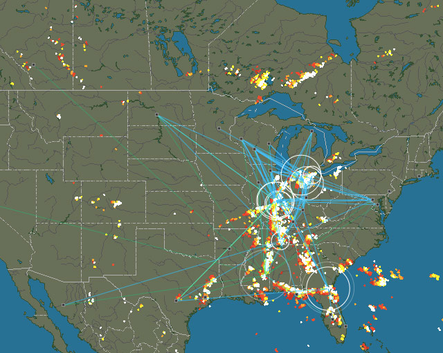
I won’t explain the specific usage of the website in too much detail; suffice it to say, it is very simple. Just select a region, such as Europe, Oceania, or the Americas, and you can see the local locations of thunderstorms and lightning.