Impact of North Korean Rocket Launches on Civil Aviation
This morning (February 7th), North Korea conducted a satellite launch using a rocket. Let’s take a look at the impact of this event on aviation.
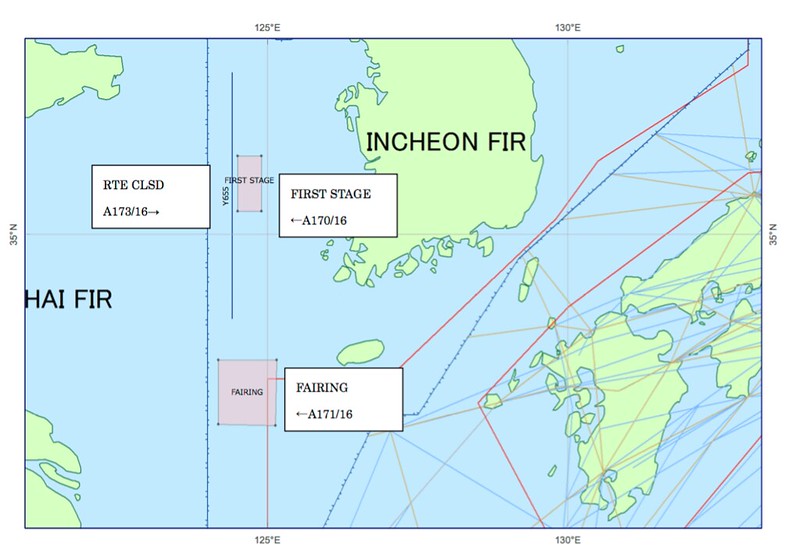
On February 3rd, South Korean authorities issued a NOTAM (Notice to Airmen).
030946 RKRRYNYX (A0170/16 NOTAMN Q)RKRR/QRPCA/IV/NBO/W/000/999/ 3542N12442E030 A)RKRR B)1602072230 C)1602250330 D)2230-0330 E)TEMPO PROHIBITED AREA ACT DUE TO MISSILE LAUNCHING BY DPRK : AREA BOUNDED BY 360400N1243000E-360400N1245400E -351900N1245400E- 351900N1243000E TO THE BEGINNING. RMK : MISSILE DEBRIS WILL FALL IN THIS AREA. F)SFC G)UNL)
030946 RKRRYNYX (A0171/16 NOTAMN Q)RKRR/QRPCA/IV/NBO/W/000/999 /3249N12439E043 A)RKRR B)1602072230 C)1602250330 D)2230-0330 E)TEMPO PROHIBITED AREA ACT DUE TO MISSILE LAUNCHING BY DPRK: AREABOUNDED BY 331600N1241100E-331600N1250900E -322100N1250800E- 322200N1241100E TO THE BEGINNING. RMK : MISSILE DEBRIS WILL FALL IN THIS AREA. F)SFC G)UNL)
030957 RKRRYNYX (A0173/16 NOTAMN Q)RKRR/QARLC/IV/NBO/E/000/999/ 3531N12425E103 A)RKRR B)1602072230 C)1602250330 D)2230-0330 E)ATS RTE Y655 CLSD DUE TO MISSILE LAUNCHING BY DPRK F)SFC G)UNL)
According to this NOTAM, based on the projected drop zones for the rocket’s first-stage booster and the payload fairing, the South Korean government designated two prohibited flight areas for the mornings between February 8th and 25th, and closed Airway Y655.
A map of the specific areas is shown below:
I just checked the FAA website, and the updated NOTAM is as follows:
A0200/16 - TEMPO PROHIBITED AREA ACT DUE TO MISSILE LAUNCHING BY DPRK: AREA BOUNDED BY 331600N1241100E-331600N1250900E-322100N1250800E- 322200N1241100E TO THE BEGINNING. RMK : MISSILE DEBRIS WILL FALL IN THIS AREA. SFC - UNL, 07 FEB 01:45 2016 UNTIL 14 FEB 03:30 2016. CREATED: 07 FEB 01:46 2016
A0194/16 - TEMPO PROHIBITED AREA ACT DUE TO MISSILE LAUNCHING BY DPRK : AREA BOUNDED BY 360400N1243000E-360400N1245400E- 351900N1245400E-351900N1243000E TO THE BEGINNING. RMK : MISSILE DEBRIS WILL FALL IN THIS AREA. SFC - UNL, 06 2345-2359, 07 0000-0330, 08 2230-2359, 09-13 0000-0330 2230-2359, 14 0000-0330, 06 FEB 23:45 2016 UNTIL 14 FEB 03:30 2016. CREATED: 06 FEB 23:50 2016
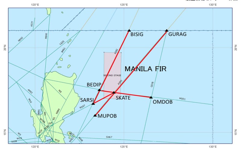
Meanwhile, Philippine authorities also issued relevant NOTAMs.
040803 RPLLYNYX (B0521/16 NOTAMN Q)RPHI/QARLC/IV/NBO/E/000/999/ 1820N12512E207 A)RPHI B)1602072130 C)1602250400 D) 2130-0400 E) DUE TO SECOND STAGE OF NORTH KOREA ROCKET LAUCH WI THE AREA BOUNDED BY 1944N12353E、1943N12451E、1700N12448E、1701N12352E THE FLW RTE SEGMENTS ARE CLSD: 1)M501 BTN OMDOB AND BEDIP 2)A590 BTN GURAG AND MUPOB 3)R597 BTN SKATE AND SARSI 4)A582 BTN BISIG AND SARSI ALTN RTE:
- MEVIN B462 (INBOUND MANILA FIR)
- N884 LEBIX (OUTBOUND MANILA FIR)
- OTHER RTE SUBJECT TO ATC APPROVAL.)
It is expected that the rocket’s second-stage booster will fall near the Philippines. Consequently, airways M501, A509, R597, and A582 will be closed.
Alternate routes are MEVIN B462 for inbound flights and N884 LEBIX for outbound flights. See the red area in the image below for details.
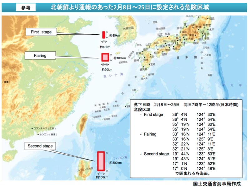
Based on this information, Japan’s Ministry of Land, Infrastructure, Transport and Tourism (MLIT) released this document.
As a result, Japan Airlines (JAL) and All Nippon Airways (ANA) altered the flight routes for some flights.
According to ANA’s announcement, flights to Manila (ANA869, ANA820), Singapore (ANA802), Jakarta (ANA [NEEDS REVIEW: likely missing flight number]), and Kuala Lumpur (ANA816) were affected.
Meanwhile, JAL’s announcement states that flights to Jakarta (JL720) and Manila (JL741, JL746) were affected, with flight times increasing by approximately 5 to 10 minutes.
The diverted flight routes can be seen in this report.
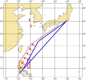
The blue line represents the normal route, while the red dotted line indicates the temporary flight route established this time to avoid the red danger zones.
End