Revisiting Airport Weather Information in Severe Weather
Here is the weather map for tomorrow morning (December 17) at 9:00 AM.
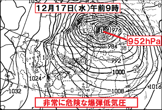
You can see that the low-pressure system near Hokkaido has reached 952 hPa; that is equivalent to a super-sized typhoon.
This low-pressure system and cold air aloft will bring stormy weather, high waves, and heavy snow. The airport weather for tomorrow is a major concern. I just saw a report from ANA (All Nippon Airways): due to snow at Sapporo New Chitose Airport, low visibility at Fukushima Airport, and strong winds at Nagoya Chubu Centrair Airport, some flights have already been affected today. So, I checked the METARs and TAFs for a few major airports to record the data, as these conditions are quite rare.
◆ANA Domestic Lines/16:30◆ This evening (Dec 16), Sapporo New Chitose Airport is due to snow, Fukushima Airport is due to poor visibility, and Hachijo Island, Nagoya Chubu, Oita, Tsushima, Iki, and Goto-Fukue Airport are due to strong winds; operations may be conditional.https://t.co/mIIp0ztdEP
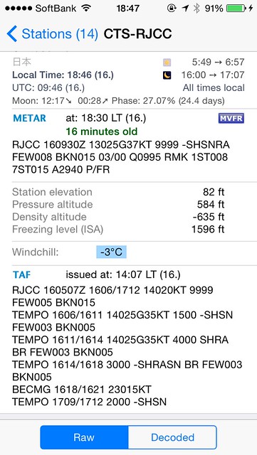
— ANA Flight Outlook Info (@ANA_flight_info) December 16, 2014First, let’s look at Sapporo New Chitose Airport. Winds from 130 degrees at 25 to 37 knots; light rain and snow; pressure 995 hPa; the snow just keeps coming.
Next, Nagoya Chubu Centrair. Wind speed 23 knots, with gusts of 34 to 44 knots. That is indeed strong, and it looks like it won’t let up tonight.

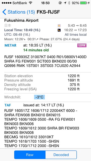
Fukushima is like this: Visibility is only 400 meters, Runway Visual Range (RVR) is 800 to 1400 meters, and the Ceiling is very low. That certainly makes landing difficult.
By the way, let’s look at nearby airports, like Haneda,
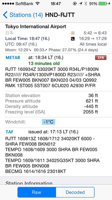 Winds are significant, Runway Visual Range (RVR) is marked for all Runways, and pressure is very low;
And Narita,
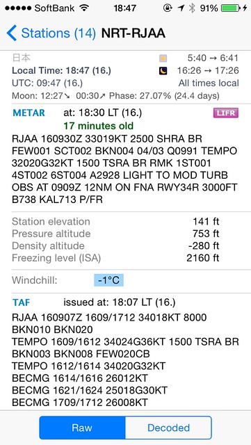 Visibility is 2500 meters, rain showers, mist, low Ceiling, and there are reports of Turbulence.
Oh, sure enough, flights are being affected. For example, this Korean Air Boeing 737 reporting wind shear went Around twice before landing. I bet the passengers were quite tense.
KAL713(HL7785):Go Around 2nd time. Finally seems to have landed (^^) pic.twitter.com/XEgBwthDkO
— Flightradar24 Watcher (@FR24spotter_jp) December 16, 2014This Air China A321 flying from Shanghai to Narita had it worse; it Diverted to Kansai Airport (KIX).
CCA919(B-1833):Landed at Kansai Airport. Good job to the crew and passengers m(__)m pic.twitter.com/6fQj615YJG
— Flightradar24 Watcher (@FR24spotter_jp) December 16, 2014Tomorrow’s weather remains to be seen; we need to keep watching.