Malaysia Airlines Flight 17 Crash Incident
I woke up early this morning, shocked by the news that Malaysia Airlines Flight MH17 (KLM codeshare flight KL4103) had been shot down. With various claims of uncertain veracity, I will refrain from commenting for now. I can only express my condolences and sympathy for the deceased and their families, and examine the facts.
Flight MH17 was a Malaysia Airlines international flight operating once daily. It departed Amsterdam, Netherlands at 12:00 noon local time and arrived at Kuala Lumpur, Malaysia at 5:50 am local time, with a flight duration of 11 hours and 50 minutes. The flight utilized a Boeing 777-200ER aircraft. The registration number of the crashed aircraft was 9M-MRD, and the model was 777-2H6ER, having entered service in July 1997. On July 17, 2014, while flying at approximately 10,000 meters over eastern Ukraine, the aircraft was shot down by a missile. All 283 passengers and 15 crew members aboard perished.

"MH17 map" by Geordie Bosanko and cmglee - http://commons.wikimedia.org/wiki/File:Mercator_Projection.svg. Licensed under CC BY-SA 3.0 via Wikimedia Commons.
There are many historical flight records for this flight on the internet. For instance, websites such as the famous FlightAware and Flightradar24 have data on it. Please refer to the links below for details. http://flightaware.com/live/flight/MAS17 http://www.flightradar24.com/data/flights/mh17/
Let’s look at its flight route from the previous day:
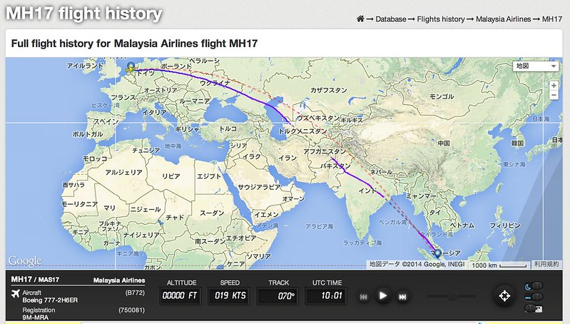 This should be a Great Circle route. After taking off from Amsterdam, the aircraft passed over Poland, Ukraine, Russia, Uzbekistan or Turkmenistan, Afghanistan, Pakistan, India, the Bay of Bengal, and finally arrived in Malaysia.
#A Great Circle is an arc on a sphere with a radius equal to that of the sphere. The Great Circle line is the curve containing the shortest path between two points on the surface of a sphere.
Looking at the aircraft 9M-MRD, there are many photos on airliners.net. The most famous is likely the “Freedom of space” blue livery used between September 2005 and September 2008.


The flight data just before the crash was as follows: Altitude 33,000 feet, Speed 490 knots, Heading 118 degrees:
Last positions of #MH17 directly from Flightradar24 database. Signal was lost around 13:21 UTC at 33,000 feet. pic.twitter.com/6gz8ECoJxI
— Flightradar24 (@flightradar24) July 17, 2014The final part of MH17 flight data on Flightaware. It cuts off at altitude 33,000ft. Location is near the northwest of Ukraine. pic.twitter.com/KqxCpTjSTq
— Flightradar24 watcher (@FR24spotter_jp) July 17, 2014Considering the extremely high probability that the aircraft was hit by a missile, the FAA announced the establishment of a no-fly zone over Ukraine. The area in the NOTAM is as follows: FLIGHT PROHIBITION. EXCEPT AS PROVIDED IN PARAGRAPHS C. AND D., NO PERSON DESCRIBED IN PARAGRAPH A. MAY CONDUCT FLIGHT OPERATIONS IN THE PORTION OF THE SIMFEROPOL (UKFV) FIR WITHIN THE FOLLOWING LATERAL LIMITS:
454500N 0345800E-460900N 0360000E-460000N 0370000E-452700N 0364100E-452242N 0364100E-451824N 0363524E-451442N 0363542E-451218N 0363200E-450418N 0363418E-445600N 0363700E-443100N 0364000E-424400N 0361600E-424700N 0340000E-424800N 0304500E-434100N 0303200E-441500N 0302400E-444600N 0300900E-455400N 0322500E-454900N 0324700E-455400N 0330600E-455600N 0332700E-455900N 0332900E-THEN ALONG THE CRIMEA BORDER TO 454500N 0345800E.
According to information on Weibo, the Dnipro Flight Information Region (FIR) has been closed. The schematic diagram provided in the same information is as follows:

On September 9th, Beijing time, the Dutch Safety Board released a preliminary report regarding the crash of Flight MH17 in eastern Ukraine. The report states that the direct cause of the crash was likely due to structural damage caused by a high-energy object from outside penetrating the aircraft. The report indicates that there was no pilot error or technical failure involved in the MH17 crash. The cockpit voice recorder, flight data recorder, and data from air traffic control all indicated that MH17 was flying normally before 13:20:03 (UTC), after which it suddenly crashed. The black box communication records show that MH17’s final transmission was “Malaysian 17, proceeding to Waypoint Romeo novermber delta”. There was no further communication after this. Ground control responded “Good Day! Radar search is normal.” The cockpit recorder showed no signs of any technical malfunction or emergency situation, nor were any technical problems heard in the warning sounds. The flight data recorder showed no warnings from any aircraft systems, and during the flight, engine parameters were consistent with the operational situation. Radio communications with Ukrainian air traffic control confirmed that the flight crew issued no emergency call. The last call was made by Ukrainian air traffic control between 13.20:00 and 13.22:02, but received no response.
This page will continue to be updated.
October 13, 2015
The Dutch Safety Board’s MH17 investigation report states that a Buk missile exploded less than one meter from the left front side of the MH17 fuselage, causing the flight to crash. The discovered warhead debris and paint characteristics match those of a Buk missile. Analysis further indicates that the missile was launched from the ground in eastern Ukraine. Full report - http://mh17.onderzoeksraad.nl/

