Methods for Individuals to Receive ACARS Signals
This week, due to the Malaysia Airlines MH370 disappearance (crash) incident, everyone knows that through the ACARS (Aircraft Communications Addressing and Reporting System), the ground can receive a lot of flight data information from the aircraft.
This site has also mentioned ACARS several times in the “Airliner Cockpit Exploration” series, such as Section 1.8 Pre-flight Procedures and Cockpit Interior, Section 2.1 5 Minutes Before Departure, Section 5.1 Descent Preparation, etc. This technology has been quite commonly used in daily airline flights.
In fact, ACARS is not some magical thing. As long as you have a receiver capable of receiving the aviation band, and a computer, you can receive and decode this data. After all, it is an unencrypted signal. Below is a brief introduction on how individuals can receive ACARS signals.
First is the receiver. For example, the Tecsun PL-660 Radio can be used to receive the aviation band.
 The Icom IC-R6 Portable Radio Receiver is also a very good choice.

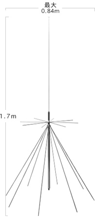
Then comes the antenna. It is best to have a relatively long antenna, as its quality directly affects the data reception quality.
The Discone Antenna D130 from First Denki Kogyo Co., Ltd. is an excellent product.
Then there is the computer. You just need a Windows PC, and install this KG-ACARS free software to receive ACARS signals.

The specific connection method is also very simple. I connected the antenna to the IC-R6 receiver via a coaxial cable, tuned the receiver to 131.250 MHz or 131.450 MHz, then used an audio cable to connect the audio signal from the receiver’s headphone jack to the computer’s LINE-IN interface, and finally started the KG-ACARS software on the computer.
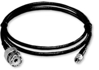
One thing to note is that because the D130 uses an MJ connector, and the IC-R6 uses an SMA connector,
so an M-SMA adapter cable was used to connect them.
The product I chose was the Diamond D1SR M-SMA Conversion Cable.
To write this blog post, I opened KG-ACARS, which I installed years ago, and looked at the signals again. When the software receives a signal, the small window in the upper right corner flashes, telling us that it received SYC or DATA. This SYC might be something similar to the engine PING signal sent to Rolls-Royce. <img src=http://cdn29.atwikiimg.com/airband/?plugin=ref&serial=3>
I don’t fully understand the specific ACARS signal format, but KG-ACARS decodes it for us, and displays very detailed data on the software such as aircraft code, flight code, departure/arrival airport codes, aircraft type, altitude, latitude/longitude, wind direction/speed, etc. By continuously tracking this data, the flight paths of various flights are displayed on the screen.
Let’s look at the specific data below. Part of it is a guess, and I invite real experts to correct me.
For example:
Lch————————[2014/03/16 15:35:55]
NH0256 (JA8968) [H1:9:D17C] MODE:Z
#DFBE24C50A890256 RJFF RJTT 0316 140615 ER124
39002-2042558236403760 7 115 638526643
777118A005030 852 82 95 4 31
777057A00 872 65 95 4 31
11551155 836 3953 843 6262 6138559
11551155 832 3839 847 6102 6201559
21161229177 2790 44541552413216 5129
20261259147 2774 44371511913476 5137
9604594 870 -11010008 1432 1675
9444631 886 -06072012 2177 1885
439 6181 732608000240B8204FF820DEA
442 6266 732608000240B8404FF8210EA
0 0 79880084-2349414081110
4 3 80490084-235031430
10 120880
16 030880
This is engine data. The data type is H1, which means information transmitted to the ground.
The first line: NH256 Flight Number (All Nippon Airways 256), JA8968 Aircraft Registration.
The second line: #DFB Flight Data Recorder data, E 24C50 Engine data code, A89 Part of the aircraft registration.
0256 Flight number, RJFF Fukuoka Airport, RJTT Haneda Airport, 0316 March 16th, 140615 14:06:15,
ER Unknown (seems to have values like ER/CL/DC/TR, guessing for enroute, climb, and descent), 124 Unknown.
The third line: 39002 Altitude 39002 feet, -204 Temperature -20.4 degrees, 255 Indicated Airspeed IAS 255 knots.
8236 Unknown, 403760 Weight (lbs), 7 115 638526643 Unknown.
The fourth and fifth lines: Lubricating oil?
777118A005030 852 Engine ID? 82 Oil pressure? 95 Temperature? 4 31 Oil quantity?
777057A00 872 Engine ID? 65 Oil pressure? 95 Temperature? 4 31 Oil quantity?
The sixth and seventh lines: Engine parameters?
1155 Engine Pressure Ratio EPR? 1155 EPR? 836 N1 RPM? 3953 EGT? 843 N2 RPM? 6262 Fuel flow? 6138 Fuel flow? 559 Unknown.
After that, it is completely incomprehensible, and I didn’t find latitude/longitude data, which is quite disappointing.
Let’s look at the H1 and 10 data sent by flight CA926 from Narita to Beijing (Aircraft Registration B-2068). I received five messages in total.
1 Lch————————[2014/03/16 15:48:02]
CA0926 (B-2068) [10:9:M30A] MODE:Z
POS160647, N 3575,E14010,—,301,28196, 64,21073, 359, -35,-255,6
Message type 10, current position N 35.75 E 140.10. According to Google Maps, the aircraft position is over Chiba, meaning it had just taken off from Narita Airport shortly before. (Narita Airport is located in Chiba Prefecture).
2 Lch————————[2014/03/16 15:54:48]
CA0926 (B-2068) [H1:1:F02B] MODE:Z
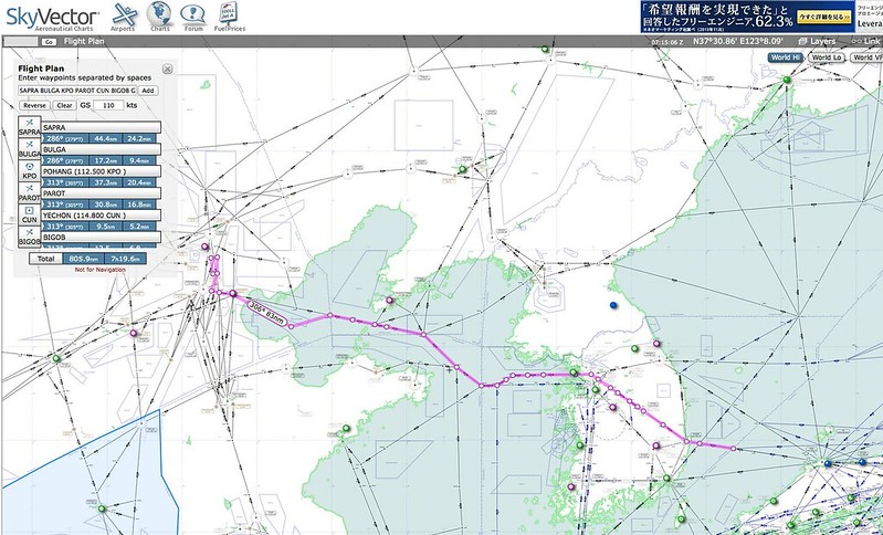
#M1BREQPWI/WQ321.320.300:SAPRA.BULGA.KPO.PAROT.CUN.BIGOB.GOTLO.
BULLS.KAKSO.KALMA.SEL.DAPTO.NOPIK.BINIL.ANSIM.DANTI.GONAV.AGAVO.
DONVO.SANKO.DOBGA.MAKNO.ALARA.ANRAT.NOKAK.CG.LADIX.DOGAR.
AA121.AA122.AA123.AA124.N39301E116420.CI01.FI01.RW01.PEK./DQ400E6D9
46 seconds later, a weather forecast request for the route was sent. The request type is M1BREQPWI requesting Predicted Wind Info (PWI). Following that is the route information, and the waypoint information is: Starting from SAPRA between Japan and Korea, along BULGA KPO PAROT CUN BIGOB GOTLO BULLS KAKSO KALMA SEL DAPTO NOPIK BINIL ANSIM DANTI GONAV AGAVO DONVO SANKO DOBGA MAKNO ALARA ANRAT NOKAK CG LADIX DOGAR AA121 AA122 AA123 AA124 N39301E116420 CI01 FI01 to Beijing, Runway 01.
Putting these points on SkyVector, the route information seems very accurate.
3 Lch————————[2014/03/16 15:56:06]
CA0926 (B-2068) [H1:2:F03A] MODE:Z
#M1BREJPWI,065546,130,112,SN101,N39301E116420.130,112,SN101,N39301E116420.130,112,SN101,N39301E116420 99AE
1 minute and 20 seconds later, another weather forecast request was sent. The weather location requested is near Langfang.
4 Lch————————[2014/03/16 15:57:01]
CA0926 (B-2068) [10:3:M31A] MODE:Z
POS160656, N 3582,E13895,—,312,28265, 72,30021, 344,-178,-480,7
55 seconds later, a position message was sent. N 35.82 E 138.95. According to Google Maps, the aircraft is over Yamanashi Prefecture.
5 Lch————————[2014/03/16 15:57:58]
CA0926 (B-2068) [H1:5:F04B] MODE:Z
#M1B4.N39301E116420.CI01.FI01.RW01.PEK./DQ40089CA
56 seconds later, M1B4 data was sent. I don’t know what that means, but the back contains the waypoints for the approach into Beijing.
I let KG-ACARS run for an hour, and the accumulated data grew more and more.
 It seems there are many data formats. Later, I checked some related materials and briefly summarized them.
Appendix ACARS (Aircraft Communications Addressing and Reporting System) is a digital data link system that transmits short messages (telegrams) between aircraft and ground stations via radio or satellite.
ACARS Frequency List: 129.000 Active OHare - Unknown 129.125 Tertiary / OHare F3 129.900 Active OHare - Unknown 130.025 Secondary / OHare F2 / ARINC Intl Flights 130.425 Auxilliary Channel for USA 130.450 Northwest Airlines / OHare F5 / USA Domestic 130.575 Active OHare - Unknown 131.125 United Airlines / OHare F4 131.250 Active OHare - Unknown 131.450 Primary Channel in Japan 131.475 Air Canada 131.525 Secondary Channel in Europe 131.550 Primary / OHare F1 131.725 Primary Channel in Europe 131.850 Europe New Channel 136.700 Active OHare - Unknown 136.750 Active, USA and Europe 136.800 United Airlines / OHare F6 136.850 SITA North American Channel 136.925 European ARINC Channel
IC-R6 SQL (Squelch) Settings: When listening to ATC with the IC-R6, the SQL (Squelch) function is very good, but when receiving ACARS, the SQL must be turned off. So you need to change the default setting from manual PUSH to MONI monitoring mode. Use SET->MONI ->HOLD to complete this.
Engine, Performance, and Weather Codes: The H1 message usually reflect data dumps from the flight data recorder (DFDAU), the flight management computer (FMC) or the Central Fault Data Indicator (CFDIU). All messages generated by these on board systems are preceded with the “#” character and a two letter code that defines which system was the source of data for the message. Typically, #CF indicates that the source was the CFDIU, #DF for the DFDAU and #M1 or #M2 for the FMC. In addition, a fourth character is displayed as either an A or B to indicate if the message is in the conventional (A) or conversational (B) mode. #DFBCRZ indicating that the data was derived from the DFDAU and contains cruise performance data.
#CFBFLR or #CFBWRN = Equipment failure #DFBTKO or #DFBTKO = Take off performance data #DFBCRZ or #DFBCRZ = Cruise performance data #DFB*WOB or #DFBWOB = Weather observation #DFB/PIREP = Pilot Report #DFBEDA or #DFBENG = Engine Data #M1AAEP = Position/Weather Report #M2APWD = Flight plan predicted wind data #M1BREQPWI = Predicted wind info request
End