Introduction to Official Websites for Airport and Route Information — ATMB of CAAC, Aviation Information Service Center, aischina.com
The Air Traffic Management Bureau of the Civil Aviation Administration of China (CAAC ATMB), abbreviated as the “ATMB”, is responsible for formulating rules, regulations, and technical standards for civil aviation air traffic management and operations in China. The main documents include:
- Aeronautical Information Publication of China Civil Aviation (NAIP)
- Aeronautical Information Publication of China Civil Aviation Amendments
- Aeronautical Information Publication of China Civil Aviation Supplements
- Aeronautical Information Circulars (AIC)
- etc.
The NAIP is divided into GEN (General), ENR (En-route), and AD (Aerodrome). It includes Aerodrome Charts, Parking Position Charts, Standard Instrument Arrival Charts (STAR), Instrument Approach Charts, Standard Instrument Departure Charts (SID), Aerodrome Obstacle Charts, Precision Approach Terrain Charts, En-route Charts, Area Charts, Air Corridor Charts, Fuel Dumping Areas, and other information.
The “Aeronautical Information Service Center” website of the ATMB (www.aischina.com) provides free materials such as NOTAMs, Aerodrome Directives, Route Manuals, and revisions to Aeronautical Charts. This is an excellent resource for aviation enthusiasts and flight simulation players.
Below is a brief introduction to how to use this website.
1. En-route (ENR) Data Published under “Flight Routes Information” on the English Information Homepage. For example, the two latest ones are Flight Routes Information Nr1302 released on Jan 28th and Flight Routes Information Nr1301 released on Dec 27th.
Taking the Jan 28th information as an example, here are 4 files provided:
- Regional Flight Routes Nr1302
- Overflying Flight Routes Nr1302
- International Flight Routes to Mainland of China Nr1302
- International Flight Routes from Mainland of China Nr1302
This information is likely what flight simulation players are most interested in, as the aforementioned route information is the most official, accurate, and up-to-date data available.
Here is an application example. In the Regional Flight Routes, you can find the route information from Beijing to Hong Kong as follows: “ZBAA-VHHH-01 RENOB G212 KR B458 WXI A461 LIG R473 WYN W18 NLG W23 ZUH R473 SIERA”
In the future, simply copy and paste the above data into the FMS of your flight simulation software to input the flight plan.
Additionally, using the Flight Planning function on the free route website SkyVector, you can intuitively display various waypoints on the route chart.
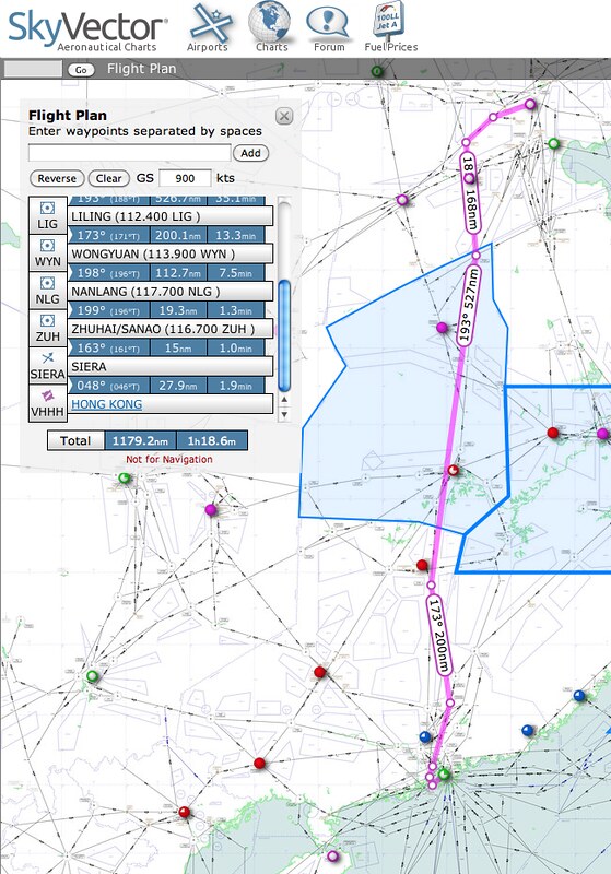
For example, by entering “ZBAA RENOB G212 KR B458 WXI A461 LIG R473 WYN W18 NLG W23 ZUH R473 SIERA VHHH” in the chart above, You can see the route displayed as a pink line on the chart.
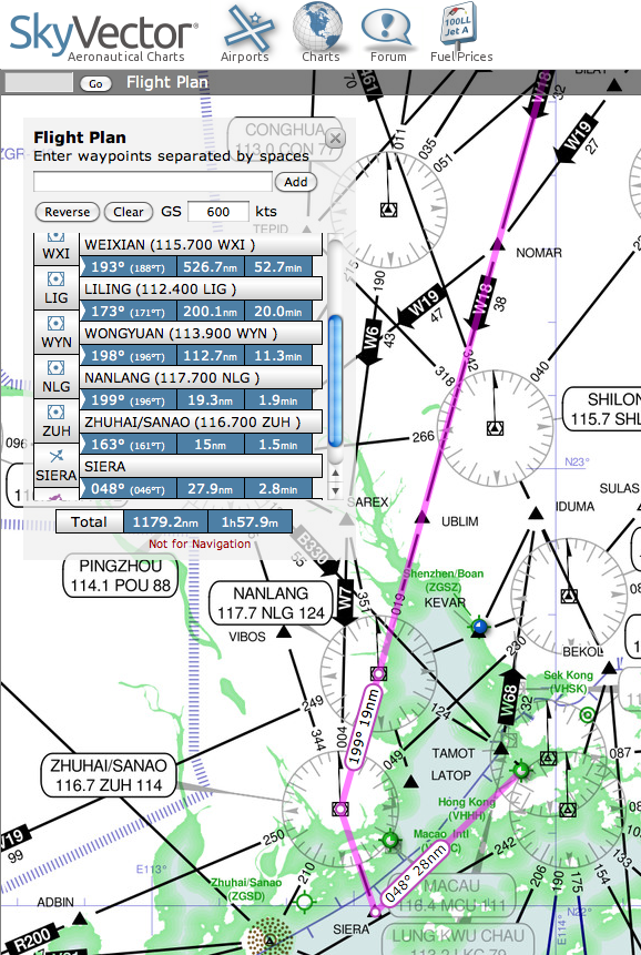
Zooming in locally, after Airway W18 arrives at the NLG (NAN LANG) station, it enters Airway W23. Upon reaching the next waypoint, ZUH (the ZHUHAI/SANAO station), it flies to the next waypoint, SIERA, and then proceeds to Hong Kong Airport via the Standard Instrument Arrival procedure. If you input a ground speed, for example, 600 knots here, based on the distance of 1179 nautical miles, you can calculate the flight time to be approximately 1 hour and 58 minutes. This information is clear at a glance on SkyVector and is very convenient to use.
2. SUP Information Various supplementary information can be found in the Hot News list page. This information is highly valuable for reference.
For instance, the latest China AIP SUP1302 was released on Jan 28th, announcing the temporary opening of Jieyang/Chaoshan Airport (ZGOW) to foreign flights. This document discloses detailed ZGOW AD information, totaling 32 pages, providing:
- ZGOW AD 2.2 Aerodrome geographic and administrative data
- ZGOW AD 2.3 Hours of operation
- ZGOW AD 2.4 Handling services and facilities
- ZGOW AD 2.5 Passenger facilities
- ZGOW AD 2.6 Rescue and fire fighting services
- ZGOW AD 2.7 Seasonal availability - Snow clearance
- ZGOW AD 2.8 Apron, Taxiways and corrected position data
- ZGOW AD 2.9 Ground movement guidance and control system and markings
- ZGOW AD 2.10 Aerodrome obstacles
- ZGOW AD 2.11 Meteorological information provided
- ZGOW AD 2.12 Runway physical characteristics
- ZGOW AD 2.13 Declared distances
- ZGOW AD 2.14 Approach and runway lighting
- ZGOW AD 2.15 Other lighting, Standby power
- ZGOW AD 2.17 Air traffic services airspace
- ZGOW AD 2.18 Air traffic services communication facilities
- ZGOW AD 2.19 Radio navigation and landing aids
- ZGOW AD 2.20 Local aerodrome regulations
- ZGOW AD 2.22 Flight procedures
As well as aerodrome charts, parking position charts, Standard Instrument Arrival Charts, Instrument Approach Charts, Standard Instrument Departure Charts, aerodrome obstacle charts, precision approach terrain charts, etc.
3. Amendment Information (AMD) AMD releases all update and amendment information for the NAIP, which can be found in the Hot News list page. The volume of information is massive. For example, in AMD1303 released on Jan 28th, Over 40 updates were released for GEN, ENR, AD, etc. Simply collecting AMD information from recent years can build a rich knowledge base.
As a flight simulation player, AMD information is absolutely essential material. The more you understand this knowledge, the more enjoyment you will get from flying. Therefore, I recommend checking the AMD whenever you have time; you will surely gain something new.
Aeronautical Information Publication China (AIP China)
End