The Joy of Reading Charts
I previously read an English article introducing how to fly actual airline routes using X-Plane, and I found it very helpful. So, I downloaded and printed out real-world charts from the internet, carefully checked the flight route according to the instructions in the article, and drew it out on paper, which deepened my understanding of the airway significantly. The routes and chart materials introduced in the above text are as follows: 1 Cincinnati/Northern Kentucky International Jodub Two Standard Instrument Departure 2 High Altitude Enroute Chart US (HI) #4
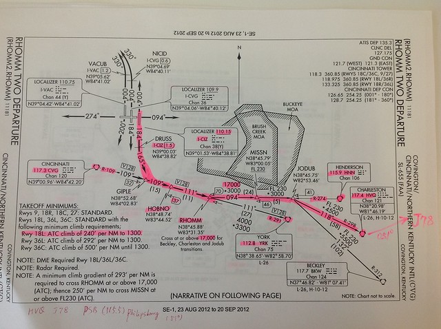 After taking off from Runway 18L, fly along the Runway heading of 184 degrees to the DRUSS fix, which is 1.5 nautical miles from the airport's I-CIZ DME (frequency 110.15),
Turn left to 165 degrees, and after reaching the GIPLE fix, turn left; the bearing here is based on the 109-degree radial of the CVG NAVAID (frequency 117.3),
After arriving at the HOBNO fix, turn towards the 291-degree radial of the YRK NAVAID (frequency 112.8),
After passing the RHOMM fix, turn left towards the 274-degree radial of the HNN NAVAID (frequency 115.9).
After taking off from Runway 18L, fly along the Runway heading of 184 degrees to the DRUSS fix, which is 1.5 nautical miles from the airport's I-CIZ DME (frequency 110.15),
Turn left to 165 degrees, and after reaching the GIPLE fix, turn left; the bearing here is based on the 109-degree radial of the CVG NAVAID (frequency 117.3),
After arriving at the HOBNO fix, turn towards the 291-degree radial of the YRK NAVAID (frequency 112.8),
After passing the RHOMM fix, turn left towards the 274-degree radial of the HNN NAVAID (frequency 115.9).
Note that there is an altitude restriction at the RHOMM fix, requiring an altitude above 17,000 feet.
After arriving at the JODUB fix, turn right to fly the 298-degree radial of the HVQ NAVAID (frequency 117.4).
Then, the segment from HVQ to the PSB NAVAID, which is the entry point for the Arrival procedure, is very simple. Just fly along Airway J78, heading 51 degrees straight towards the northeast.
Finally, the Arrival chart.
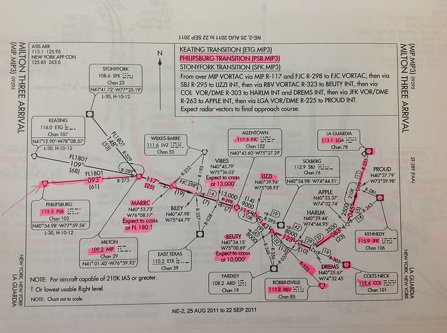 After passing the PSB NAVAID, turn right to the 273-degree radial of the MIP NAVAID (frequency 109.2),
After reaching MIP, turn right to the 117-degree radial of the ETG NAVAID (frequency 116.0), and fly to the MARRC fix.
Note that the altitude requirement at the MARRC fix is FL180, so generally speaking, the aircraft must have already started the Descent process before MARRC.
After passing MARRC, adjust to the 298-degree radial of NAVAID FJC (frequency 117.5), and reduce altitude to 13,000 feet at the VIBES fix.
After passing FJC, make a fine adjustment to the 115-degree radial of NAVAID FJC (frequency 117.5), and fly to the LIZZI fix.
After arriving at the LIZZI fix, turn right to the 323-degree radial of the RBV NAVAID (frequency 113.8),
Fly towards the BEUTY fix, and reduce altitude to 10,000 feet.
After arriving at the BEUTY fix, turn left to the 303-degree radial of the COL NAVAID (frequency 115.4), and fly to the DREMS fix.
After arriving at the DREMS fix, continue turning left to fly the 263-degree radial of the JFK NAVAID (frequency 115.9),
After arriving at the APPLE fix, enter on the 225-degree radial of the LGA NAVAID (frequency 113.1) and track the ILS signal to land.
This route looks really complicated with so many NAVAIDs; it would be very troublesome to adjust the flight manually.
Fortunately, this data is now logged in the database. During commercial flight, pilots just need to call them up on the FMC,
The computer will also constantly correct the heading based on navigation information and NAVAID data during the flight, so the burden on pilots is not so high,
But as an enthusiast, actually looking at specific charts is quite interesting.
End
After passing the PSB NAVAID, turn right to the 273-degree radial of the MIP NAVAID (frequency 109.2),
After reaching MIP, turn right to the 117-degree radial of the ETG NAVAID (frequency 116.0), and fly to the MARRC fix.
Note that the altitude requirement at the MARRC fix is FL180, so generally speaking, the aircraft must have already started the Descent process before MARRC.
After passing MARRC, adjust to the 298-degree radial of NAVAID FJC (frequency 117.5), and reduce altitude to 13,000 feet at the VIBES fix.
After passing FJC, make a fine adjustment to the 115-degree radial of NAVAID FJC (frequency 117.5), and fly to the LIZZI fix.
After arriving at the LIZZI fix, turn right to the 323-degree radial of the RBV NAVAID (frequency 113.8),
Fly towards the BEUTY fix, and reduce altitude to 10,000 feet.
After arriving at the BEUTY fix, turn left to the 303-degree radial of the COL NAVAID (frequency 115.4), and fly to the DREMS fix.
After arriving at the DREMS fix, continue turning left to fly the 263-degree radial of the JFK NAVAID (frequency 115.9),
After arriving at the APPLE fix, enter on the 225-degree radial of the LGA NAVAID (frequency 113.1) and track the ILS signal to land.
This route looks really complicated with so many NAVAIDs; it would be very troublesome to adjust the flight manually.
Fortunately, this data is now logged in the database. During commercial flight, pilots just need to call them up on the FMC,
The computer will also constantly correct the heading based on navigation information and NAVAID data during the flight, so the burden on pilots is not so high,
But as an enthusiast, actually looking at specific charts is quite interesting.
End